Slower period, best next week

Bali and Mentawais forecast by Craig Brokensha (issued Tuesday 7th August)
Best Days: Wednesday morning, the weekend, Wednesday afternoon next week onwards
This week and next (Aug 8 - 17)
Bali: Oversized surf over the weekend, easing back into Sunday ahead of new long-period S/SW groundswell yesterday and this morning.
This swell was much more south and as a result didn't get into protected spots anywhere near as well while also being much smaller east of Bali, but south magnets were still large.
This is the biggest we'll see the surf for the coming period, with the Indian Ocean finally quietening down, resulting in much smaller surf compared to what we've seen the last few weeks.
Looking at tomorrow and we'll see exposed south facing breaks easing from 4-6ft, smaller into Thursday and bottoming out later in the day and Friday morning.
Our next noticeable increase in swell is due over the weekend.
 Later Friday a small and inconsistent background SW groundswell will likely be seen, but a better pulse of swell is due to fill in Saturday and peak later in the day/overnight.
This swell is being generated by a small and tight but slow moving mid-latitude storm pushing east through the southern Indian Ocean.
This should provide 4-6ft surf across magnets later in the day Saturday, weaker but holding a similar size Sunday as some mid-period reinforcing swell fills in from a strong fetch of SW winds projecting towards Indonesia on the backside of the small tight low.
Winds are due to relax into Thursday before strengthening again from later Friday, remaining strong out of the E/SE until mid week before easing and swinging more SE.
As this happens we'll see the weekend's swell dropping right away into Tuesday, with some better swell energy due into the middle to end of next week.
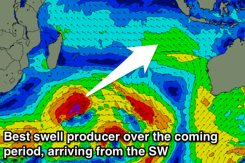
The first will be a long-period SW groundswell produced by another mid-latitude low, but this one will be stronger and project further north than the system linked to the weekend's swell, though being more distant.
Still we should see a good long-period SW groundswell starting to build through Wednesday, very inconsistent and reaching 5-6ft by dark on the sets, peaking Thursday to a good 6ft, with the odd sneaker likely at times.
We may see a larger swell into the end of the week/weekend from stronger trailing frontal activity, but more on this Thursday.
16 day Bali Forecast Graph
16 day East Java Forecast Graph
16 day Sumbawa Forecast Graph
Ments: Our current average mix of mid-period S/SE swell and SE winds should ease back over the coming days as the strong high pressure ridge to our south has relaxed.
We then look to the new SW swell due later week, with the swell arriving Thursday afternoon and peaking through Friday across our region. Fun sets to 4-6ft are due across swell magnets with lighter SE breezes, easing back slowly through the weekend.
Monday looks much smaller, with the swell bottoming out into Tuesday morning.
The better long-period SW groundswell for mid-week is looking really good for the Mentawais, with it due to arrive through Wednesday and kick to a strong 6ft+, easing slowly through Thursday and Friday morning.
We may see those pesky SE winds kick back in through the week, limiting the best waves to more protected locations.
We then may see follow up S/SW groundswell next weekend, but we'll have a closer look at this Thursday.
16 day Mentawai forecast graph
16 day Nias forecast graph
16 day South Sumatra forecast graph