Large surf all week and into the weekend

Bali and Mentawais forecast by Craig Brokensha (issued Tuesday 15th August)
Best Days: Every day across Bali for experienced surfers, protected spots around the Ments over the coming period
This week and next (Aug 16 - 25)
Bali: We've got large surf breaking across the region today, with a building SW groundswell yesterday being replaced by a stronger S/SW groundswell.
Exposed breaks are due to build to 8ft+ through this afternoon, holding through tomorrow morning ahead of a slight drop in size later in the day.
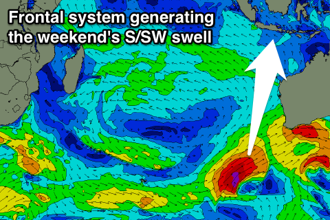 This swell and a large reinforcing pulse for Thursdayhave been generated by a broad and multi-centred low sitting south-west of WA since the weekend. Various fetches of gale to severe-gale winds have been aimed through our southern swell window, with a final stalling fetch of severe-gale to storm-force S/SW winds producing a good S/SW groundswell for Thursday and Friday.
We should see exposed breaks building back to 8ft+ through the day Thursday ahead of a drop back from 8ft sets Friday morning.
One final pulse of S/SW groundswell is due over the weekend, produced by a vigorous polar front projecting up towards WA today and early tomorrow. This front will be just within our southern swell window and should produce a large S/SW groundswell for Saturday afternoon, building to 6-8ft through the mid-late afternoon, easing from a similar size Sunday morning.
Looking at the conditions over the coming week and moderate to fresh SE trades are due to ease into Friday and Saturday before increasing out of the E/SE Sunday. Early each morning local land breezes will create variable winds.
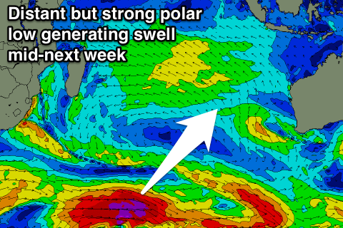 Longer term there's nothing major on the cards until mid-next week, with a large but inconsistent S/SW groundswell fills in. This is forecast to be generated by a vigorous but distant polar frontal progression in the Heard Island region late week, but more on this Thursday.
16 day Bali Forecast Graph
16 day East Java Forecast Graph
16 day Sumbawa Forecast Graph
Ments: Currently a large powerful S/SW groundswell should be providing 8ft+ sets across exposed breaks. We'll see this swell easing off through tomorrow ahead of the large reinforcing S'ly groundswell buildingThursday and peaking Friday morning.
This secondary swell is due to be a touch smaller with 6-8ft waves due across south facing breaks, easing through Friday afternoon, down further into Saturday and Sunday.
From tomorrow a slight increase in E/SE winds are due across the region, persisting through Friday before freshening out of the SE from the weekend as a strong high pressure ridge develops south of us.
This will produce some moderate sized S/SE trade-swell for our exposed breaks from Sunday afternoon through Wednesday, biggest Monday as a small mid-latitude low projects north towards us tomorrow evening and Thursday.
South facing spots should see 4-6ft sets, easing back Tuesday and further Wednesday.
The inconsistent S/SW groundswell due mid-week should build to a similar 4-6ft across exposed breaks later Wednesday though with more power, easing gradually from Thursday.
16 day Mentawai forecast graph
16 day Nias forecast graph
16 day South Sumatra forecast graph