Large surf from tomorrow

Bali and Mentawais forecast by Craig Brokensha (issued Thursday 10th August)
Best Days: Every day over the coming period for experienced surfers
This week and next (Aug 11 - 18)
Bali: Small fun surf this morning, but the forerunners of a large new S/SW groundswell should be seen later today, building further through tomorrow towards a peak into the afternoon.
This swell was generated by a strong mid-latitude front pushing towards WA and up across it's North West.
With this the swell will be consistent, building to 8ft across exposed breaks through tomorrow afternoon before easing from 6-8ft or so Saturday morning, further Sunday.
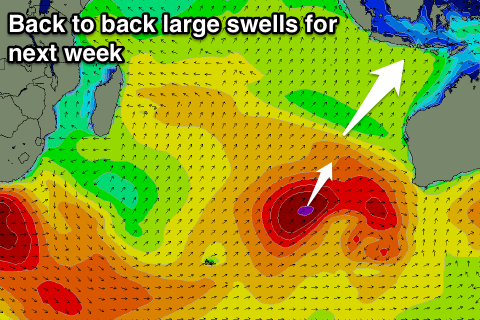 We then look to our run of large back to back groundswells next week.
This run of swell will be linked to a broad and stationary low pressure system stalling west-southwest of WA, with multiple embedded lows and fronts.
The first low will project a fetch of gale to severe-gale SW winds towards our swell window today, dipping away to the south-east tomorrow as a secondary stronger system projecting a fetch of severe-gale S/SW winds up slightly more in our southern swell window.
We'll see a good SW groundswell initially created for Monday, building to 6ft to possibly 8ft across exposed breaks into the mid-late afternoon.
The larger S/SW groundswell is then due Tuesday with larger 8ft+ sets across exposed breaks through the day, easing back temporarily into Wednesday.
One final pulse of large but more prolonged S/SW groundswell is then due later Wednesday and more so Thursday, produced by a stalling fetch of severe-gale to storm-force S/SW winds at the base of the broad low.
We should see sets persisting at 8ft all day, easing very slowly from the 6-8ft range Friday and further Saturday.
Beyond this the Indian Ocean goes a little quiet to it'll be worth capitalising on these swells.
We're looking at moderate to fresh SE trades over the coming period (variable each morning) and easing off later next week for a stint.
16 day Bali Forecast Graph
16 day East Java Forecast Graph
16 day Sumbawa Forecast Graph
Ments: Starting from a slow base this morning the swell should be on the build out of the S/SW this afternoon, peaking tomorrow in the 6ft+ range across exposed breaks. Funky S/SE winds today will become more variable and remain so into the weekend as the swell slowly eases.
Next week's swells are looking great, with the biggest and best pulse due Tuesday, similar to Bali.
The first S/SW swell for Monday should build to 6ft+ across exposed breaks into the afternoon, with Tuesday'sincrease revealing larger 8ft+ sets across south facing breaks.
A drop in size is due through Wednesday, with the reinforcing energy for Thursday coming more from the S'th and in the 6-8ft range.
Winds look to take a slight E/SE-SE tendency from early next week, favouring more protected breaks rather than south magnets.
16 day Mentawai forecast graph
16 day Nias forecast graph
16 day South Sumatra forecast graph