Easing S/SW swell from tomorrow, large new S/SW groundswell late next week

Bali and Mentawais forecast by Craig Brokensha (issued Thursday 20th October)
Best Days: Friday through Monday morning before the swell bottoms out Bali, Wednesday, Friday onwards, Ments Friday/early Saturday, Tuesday and then Friday onwards
This week and next (Oct 21 – 28)
Bali: Currently a strong and inconsistent S/SW groundswell should be filling in across the islands, with exposed south facing breaks expected to reach 5-6ft later this afternoon/evening with possibly the odd bigger 8ft bomb, dropping back from a similar size tomorrow morning, further into Saturday.
The weekend should see wave heights hover around 4-5ft for the most part as some reinforcing S/SW groundswell fills in.
A slow drop in size will then be seen Monday and further Tuesday.
The inconsistent SW groundswell for Wednesday is still on the cards, with it being generated by a stalling mid-latitude south-east of Madagascar, in our far swell window.
With the west in the swell most breaks should see an even spread in size, coming in at an inconsistent 3-4ft+ through the morning, easing later with Thursday being small again.
As talked about last update a new large S/SW groundswell was on the cards for later next week.
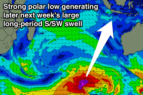 This swell is shaping up real nice with a vigorous polar low expected to form around the Heard Island region this weekend, projecting a fetch of severe-gale to storm-force W/SW winds towards the Australian mainland.
A large long-period S/SW groundswell should result, with the fore-runners arriving late Thursday ahead of the groundswell proper Friday.
Exposed breaks should build to a large 6-8ft+ through the mid-late afternoon, easing from 6-8ft Saturday morning, further Sunday.
Beyond this moderate amounts of S/SW swell are on the cards for early to mid the following week, but more on this next update.
Coming back to the expected winds over the coming period, and moderate to fresh E/SE trades through tomorrow and Saturday will tend variable into Sunday and remain so right until next weekend. From here weak trades are due to kick back in.
16 day Bali Forecast Graph
16 day East Java Forecast Graph
16 day Sumbawa Forecast Graph
Ments: Similar to Bali, the inconsistent S/SW groundswell should be filling in across the region today, peaking this afternoon to 4-5ft at south facing breaks before easing off into tomorrow, with small surf Saturday through Monday.
The SW groundswell will arrive a day earlier in the Ments, building later Monday and peaking Tuesday afternoon to 3-5ft. A slow drop should then be seen Wednesday with the swell bottoming out again Thursday.
Winds will remain variable tomorrow, but a moderate to fresh NW'ly will kick up through Saturday afternoon and persist until Tuesday before slowly easing off and tending more variable mid-next week.
The large S/SW groundswell due late week is expected to be more south in direction across the Ments but still solid, building to 6ft+ across south facing breaks Friday afternoon, easing from a similar size Saturday morning and further into Sunday. Winds should be generally variable through this swell episode.
16 day Mentawai forecast graph
16 day Nias forecast graph
16 day South Sumatra forecast graph