Funky mix of S/SE and S/SW swells ahead of large better swells from Sunday

Nias, Mentawai, South Sumatra forecast by Craig Brokensha (issued Tuesday 12th July)
Best Days: South swell magnets Wednesday, Thursday and Friday morning, later Saturday onwards
This week and next (Jul 13 - 22)
Small levels of funky S/SE swell have filled in today from a stationary and broad fetch of SE trades to our south, under Eastern Indonesia.
This swell is expected to continue tomorrow and Thursday before easing off into Friday as the ridge weakens and breaks down. Exposed south facing breaks should offer 3-4ft+ sets tomorrow and Thursday before easing. Some small background S/SW groundswell will also be in the mix Thursday to 3-5ft, easing back through Friday.
NW winds will favour south-east facing breaks before tending more variable from the weekend.
From Sunday we'll enter a very active period of surf, probably the largest sustained run of swell and from the S/SW this season.
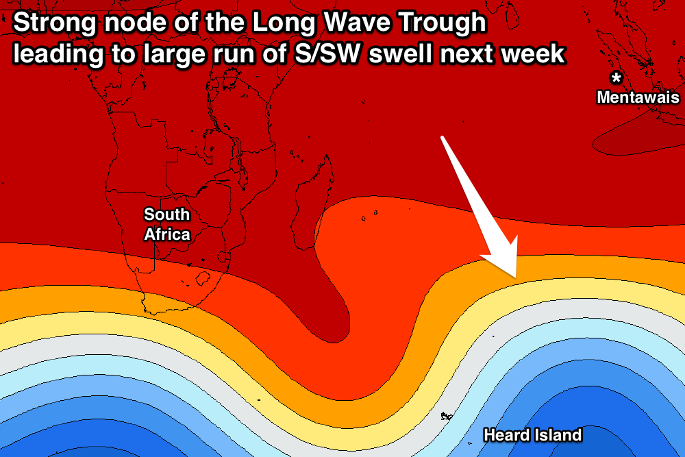 This will be related to a strong amplified node of the Long Wave Trough developing across the central to south-eastern Indian Ocean over the coming days.
With this we'll see back to back to back polar fronts directed one after the other up high into the Indian Ocean, generating large long-period pulses of S/SW groundswell.
The first frontal system is already developing north of Heard Island with a fetch of strengthening gale to severe-gale SW winds projecting towards the islands.
This should produce an initial large S/SW groundswell for the weekend, arriving Saturday afternoon and kicking to 5-6ft by dark ahead of a peak Sunday to the 8ft+ range across exposed south facing breaks.
A drop in size is due into Monday, while a secondary pulse of larger S/SW groundswell is due on dark and more so into Tuesday morning, followed by a third into Wednesday.
These additional pulses will be generated by secondary stronger and broader polar fronts pushing up on the tail of the original system, on top of an already active sea state.
Tuesday's pulse should come in at a larger 8-10ft across exposed breaks, with the largest increase Wednesday looking to be an easy 8-10ft+. Variable winds are likely to continue through most of next week with a S/SE bias Monday and W'ly bias Thursday and Friday as the swell starts to ease. More on this Thursday.
16 day Mentawai forecast graph
16 day Nias forecast graph
16 day South Sumatra forecast graph
Comments
The Ments is also looking to see lots of size but more from a S/SW angle.
mate any chance of a quick swell report for the telos islands from 30th july through till the 8th august period sec and swell height heading there for a trip. thx mate
A bit too far out sorry, give us a reminder later next week.