Good swell pulses, W-NW winds until Monday

Nias, Mentawai, South Sumatra forecast by Craig Brokensha (issued Thursday 20th October)
Best Days: Every day over the coming period
This weekend and next week (Apr 22 - 29)
We should be seeing a new S/SW groundswell across the coast today, but this will drop back overnight and into tomorrow morning as winds start to increase from the NW to W. This will limit surfing options across the islands.
Into Saturday a kick in background swell is due ahead of a stronger pulse of long-period S/SW groundswell later in the day, peaking Sunday morning.
This swell generated earlier this week should provide 5-6ft sets across exposed breaks but fresh NW winds look to limit options.
The swell is due to drop through Monday as winds ease and tend more variable.
Our final pulse of groundswell from the progression of polar fronts between Heard Island and South Africa is due later Monday and Tuesday morning with exposed breaks kicking back to an inconsistent 5-6ft again under variable winds.
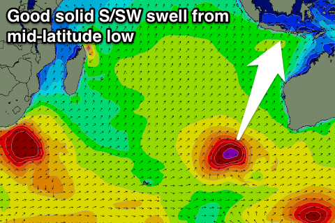 For the rest of the week, an acute but good S'ly groundswell is due, generated by a tight and intense mid-latitude low firing up south-west of WA. A fetch of severe-gale to storm-force S/SW winds will be projected towards eastern Indonesia, with us seeing S'ly groundswell spreading radially towards us.
The swell should kick strongly Wednesday afternoon/evening, reaching 5-6ft across south facing breaks by dark, and easing from a similar size Thursday morning, further into Friday. Variable winds are due to persist Wednesday and Thursday with a tendency to the W/NW through Friday and the following weekend. More on this next update.
16 day Mentawai forecast graph
16 day Nias forecast graph
16 day South Sumatra forecast graph