Smaller swells with average winds, much better from Thursday

Nias, Mentawai, South Sumatra forecast by Craig Brokensha (issued Thursday 20th August)
Best Days: Protected breaks over the coming days, with a better swell Monday morning and better surf from Thursday afternoon
This week and next week (Aug 21 – 28)
The coming days will continue to see small to moderate levels of background swell with unfavourable S/SE winds limiting surfing options to more protected breaks.
Later Sunday and Monday's inconsistent SW groundswell is still on track with it due to peak to an infrequent 5-6ft across swell magnets early Monday before easing into the afternoon and further down Tuesday, bottoming out Wednesday.
Thursday's larger S/SW groundswell has unfortunately been downgraded a touch with the vigorous polar frontal progression generating it now becoming disjointed. In saying this wind speeds will still reach the severe-gale range in the first system, with the secondary system being a touch weaker.
We'll see two pulses of moderate to large S/SW groundswell, the first building Thursday and reaching 5-6ft+ across exposed breaks into the evening, and then holding Friday. The secondary swell is then due over the weekend, keeping 6ft sets hitting exposed breaks.
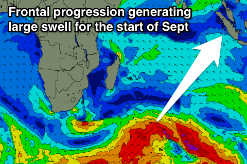 The secondary groundswell event due for the start of September is still on track, with a much stronger, broader and multi-stage frontal progression forecast to fire up through the Indian Ocean during next week.
A couple of larger S/SW groundswell pulses are expected, the first for Monday building to 6-8ft across exposed breaks, with a secondary similar pulse Tuesday evening/Wednesday morning.
The S/SE winds are due to ease back from next weekend, but we'll have a closer look at this and the swells on Tuesday.
16 day Mentawai forecast graph
16 day Nias forecast graph
16 day South Sumatra forecast graph