Indonesia/Maldives forecast Apr 24

Indian Ocean Basin analysis by Craig Brokensha (issued Thursday 24th April)
This week through next (Apr 25 - May 2)
Our large SW groundswell came in right on cue through yesterday with it pushing in strongly through the morning, with solid sets holding this morning.

We should see the swell ease off over the coming days, with our next increase in size due through Saturday afternoon and Sunday.
Our long-range S/SW groundswell from a strong polar low forming east of the Heard Island region should generate Saturday afternoon’s building energy, while a small tight low that formed off the Western Australian coast will produce a more consistent mid-period S’ly swell for later in the day but more so Sunday.
The size from the mid-period energy looks strongest Sunday, though locations east of about Bali will miss out on the size thanks to the blocking effects of Exmouth.
Make the most of these swells as the outlook from early next week is down, down, down.
There’s nothing of real note besides some small to moderate sized, inconsistent SW swells for Wednesday afternoon/Thursday morning, then later Friday/Saturday.
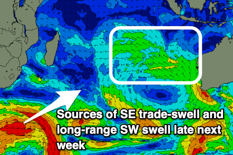
As touched on in Tuesday’s notes, the sources are healthy but distant storms that fired up south-east of South Africa the last couple of days, with the second of the two likely to generate the most size.
Otherwise, a strong polar low skirting the shelf after forming south of South Africa early next week may generate a large, long-period SW groundswell for mid-next week, but more on this Tuesday.
Looking at the local winds, and weak trades are due to develop over the coming days, strengthening later next week but we’ll confirm this next week.
For the Mentawais, we’ve got NW winds but these should ease back over the coming days, tending variable from the weekend and even tending SE through next week.
----------------------------------------------
Maldives:
The surf is slowly easing across the region but we should see some new S/SE trade-swell arriving through the weekend, building later Saturday ahead of a peak Sunday.
This has been generated by a healthy trade-wind fetch south-southeast of us, but a broader and more substantial fetch forming further east, off the Western Australian coast over the coming days should produce some better SE trade-swell that’s due to arrive through Tuesday next week.
This will bring more size and power before easing slowly mid-late week as the trade-wind fetch slowly weakens.
Across the southern atolls, the S/SW swell energy from the dual systems firing up south of South Africa should arrive next week, with the first pulse due later Monday, peaking Tuesday morning ahead of the secondary pulse later Wednesday/Thursday.
The current gusty W’ly winds will persist through the end of the week and weekend, slowly easing through next week.
Eastern Indonesia:
Easing SW groundswell over the coming days.
Moderate + sized, inconsistent S/SW groundswell building Saturday, reaching 4-6ft across exposed breaks later, easing Sunday.
Moderate + sized mid-period S’ly swell for later Saturday, peaking Sunday to 5-6ft (smaller east of Bali).
Easing surf early next week.
Small to moderate sized, inconsistent SW swell for Wednesday afternoon/Thursday morning to the 4ft range.
Small to moderate sized, inconsistent SW swell for later Friday/Saturday morning to 4-5ft across exposed breaks.
Weak E/SE-SE trades kicking in tomorrow, strengthening later next week (variable offshore each morning).
Uluwatu 16-day Forecast Graph/WAMs
Western Indonesia/Mentawais/South Sumatra:
Easing SW groundswell over the coming days.
Moderate mix of S’ly swells building later Saturday, peaking Sunday to 4-6ft across exposed breaks, easing thereafter,
Small to moderate sized, inconsistent SW swell for Wednesday in the 4ft range.
Small to moderate sized, inconsistent SW swell for Friday in the 4-5ft+ range.
Easing NW winds tomorrow, variable from the weekend, tending SE through next week.
Mentawai 16-day Forecast Graph/WAMs
Maldives:
Building S/SE trade-swell later Saturday, peaking Sunday to 3ft+, easing slowly Monday.
Slightly stronger S/SE swell for Wednesday to 4ft, easing into the end of the week.
Moderate sized S/SW swell for later Monday, peaking Tuesday to 3-4ft across the southern atolls.
Secondary pulse of S/SW swell later week to 4ft+ across the southern atolls.
Fresh W winds this week and weekend, easing slowly next week.
Comments
Latest notes are live.
Thanks Craig , some 6ft sets this morning, ENE wind from sunup to 8.00am before a NW storm blew in , managed to get a few but frustrating watching all this swell going to waste at this spot with these winds . Shows how a boat has big advantages in these circumstances . Nearest wave that’s offshore in these winds is a long long way away . Can’t win them all . Looking forward to Sunday which will possibly be the best day of the trip .
Thanks Supa, you're in the Ments yeah?
Yes , north end , lovely E wind this morning and overhead waves 4ft , some bit bigger , going around to the NE now and no doubt NW will kick in but we had over 3 hours of really nice waves .
Sounds fun as man, hope sunday pumps for ya!
Sunday delivered , didn’t quite get to 6ft but was pretty close, long lulls but when the came were pretty bloody good, lots more power in the swell this morning, put in close to 5 hours straight as everyone else went in for breakfast, I just couldn’t paddle away from waves like that with just me out, surfed 1.5 hours on my pat malone ,some 350 metre rides . WOOHOO, thanks for always delivering on your reports Craig , other forecasts were saying 3ft .
Saturday lunchtime delivered some 6ft bombs at one of the Bali swell magnets. Long time between sets made it hard to line up properly, as I was out there on my own! No wind too until early arvo.
Late Wed and Thurs was also a strong 4-6ft but at the other end of the island. Another strong groundswell, of which the lack of trades meant it was clean all day.