Indonesia/Maldives forecast Nov 26
Indian Ocean Basin analysis by Craig Brokensha (issued Tuesday 26th November)
This week through next (Nov 27 - Dec 6)
A fun pulse of size later Sunday eased back slowly through Monday with this morning coming in a little smaller again but a reinforcing pulse of mid-period S/SW energy is due later today, easing into tomorrow morning again.
There’s been a slight upgrade in the S/SW energy due into Thursday though with the trailing front through the Indian Ocean, South West of WA coming in a touch stronger.
With this 6ft sets are likely on the magnets before easing into Friday morning.
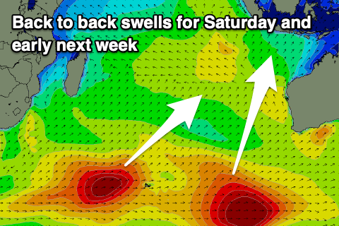
We then look at the long-period S/SW groundswell due on Saturday, with the forerunners of this swell expected to build Friday afternoon.
The polar low linked to the swell was quite significant with storm-force W’ly winds generated around the Heard Island region, in our southern swell window.
While building later Friday, the peak is due into Saturday, and the models look like they are undercooking the size a little. Magnets should see inconsistent 6-8ft sets at the peak, with an easing trend then due into Sunday.

A secondary pulse of reinforcing, SW groundswell is then due later Monday but more so Tuesday morning, produced by a secondary frontal system firing up on the backside of the polar low. Fetches of gale to severe-gales should generate a good angled but inconsistent swell peaking Tuesday.
Beyond this a larger S/SW swell is on the cards for later Wednesday/Thursday, with nothing much beyond this. So make the most of the coming swells.
Over in the Mentawais, a tropical depression sitting west of the islands is bringing localised, low quality W/NW swell though the depression is slowly weakening and this should result in a slow drop in size into the weekend and further next week.
Strong local NW winds will persist tomorrow before easing off slowly from Thursday, weaker into the weekend and next week but still lingering out of the north-western quadrant.
----------------------------------------------
Maldives: A great fetch of strong E/SE-SE trade-winds feeding into the south of the tropical depression to the south-east of the region is generating moderate levels of SE trade-swell that should persist all week.
Our stronger intensification over the coming days is on track to then deliver some larger, stronger period energy into the weekend (building Friday), before slowly backing off through next week as the trade strength slowly dissipates.
Otherwise, the strong frontal progression currently west of the Heard Island region should produce some good S’ly groundswell for the southern atolls later Saturday but more so Sunday before easing next week.
Winds are expected to slowly strengthen over the coming days and weekend from the W/NW before backing off slowly into next week.
Eastern Indonesia:
Small-moderate sized, mid-period S/SW swell this afternoon, reaching 3-5ft across exposed breaks, easing tomorrow.
Reinforcing mid-period S/SW swell Thursday to 6ft across exposed breaks, easing Friday.
Large, long-period S/SW groundswell showing later Friday but building Saturday, peaking to an inconsistent 6-8ft into the afternoon on the magnets.
Reinforcing large sized SW groundswell later Monday/Tuesday to 6ft to occ 8ft across exposed breaks.
Larger S/SW swell likely Thursday to 8ft across exposed breaks, smaller thereafter.
Variable, light, locally offshore morning winds ahead of weak, onshore afternoon breezes.
Uluwatu 16-day Forecast Graph/WAMs
Western Indonesia/Mentawais/South Sumatra:
Mix of S/SW and W’ly swells this week with strong NW winds tomorrow, easing slowly in strength from Thursday.
Long-range, inconsistent S’ly groundswell building Saturday, reaching 4-6ft, easing Sunday.
Reinforcing S/SW groundswell Monday afternoon to 6ft to occ 8ft across exposed breaks.
Large S’ly swell late week to 6ft+ across exposed breaks.
Easing winds next week but lingering out of the NW-W/NW.
Mentawai 16-day Forecast Graph/WAMs
Maldives:
Moderate levels of SE trade-swell this week to 4ft+ across exposed breaks.
Stronger swell for Friday and into the weekend to 4-5ft on the sets, easing slowly next week.
Moderate sized S’ly groundswell for later Saturday but more so Sunday to 4ft+ across the southern atolls, peaking into the afternoon.
Slowly strengthening W/NW winds this week, strongest on the weekend, easing through next week.


Comments
Latest notes are live.
Thank you Craig , doing a safari up the east coast of Bali next week and loving this report.
Just got back from Bali after a week of great waves Ulus first few days overhead waves great conditions then somewhere more exposed the last 4 days one day the best ive ever had it one evening so glassy couldnt see the sets coming. Two good surfs a day and a great successful trip. All this after I said I would never go back.
Check charts read Craigs surf report and go offseason might not be giant but certainly worth it.
A great week it was, eh!
Always go off season these days, Nov/Dec. Less crowds, last Dec never saw a drop of rain.
Cams looked good last week, got here this week and skunked last 4 days.
Checked wind conditions, appears similar to last week.
So... what's different about the swell?
No cams showing decent waves or even surfable options except Keramas, with such a small take-off zone and a crowd like Noosa at times through the day.
Ahh bummer. Seemed like the long period stuff on Friday afternoon was hitting some spots and not others while also making waves perform differently as well.
Full on wet season weather at the moment. Lots of creeks and rivers flushed out and pretty much everywhere looking brown and full of rubbish.
This time of year is always a gamble.