Indonesia/Maldives forecast March 19

Indian Ocean Basin analysis by Craig Brokensha (issued Tuesday 19th March)
This week through next (Mar 20 - 29)
After a general easing trend on the weekend, some inconsistent mid-period SW swell should be on the build across the region today, peaking this afternoon before easing tomorrow.
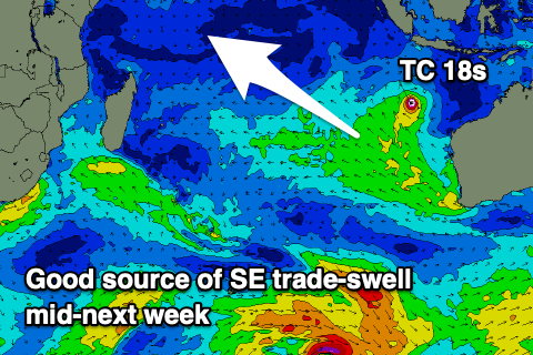
There should be some mid-period SW swell also in the mix tomorrow, generated by Tropical Cyclone 18s that’s been meandering around to the south of Indonesia since the weekend.
No major size is expected from this cyclone but the swell will be noticeable in the water across eastern Indonesia.
Into the evening and more so Thursday, our pulse of inconsistent S/SW groundswell is due, generated by a late forming low to the south-west of Western Australia on the weekend.
This swell was downgraded a little across Western Australia, with a similar downgrade due across Indonesia. In saying this, an uptick in size and power should be seen Thursday before easing into Friday and the weekend.
Other than a smallish, inconsistent background SW groundswell for Sunday/Monday, the outlook is slow, but this will be in lead up to what looks to be a large S/SW groundswell at the end of the month. We’ll have a closer look at this on Thursday.
Over to the Maldives and S’ly swell is most dominant across the southern atolls, with smaller levels of SE trade-swell across northern locations.
Both the S’ly and SE trade energy should ease into tomorrow morning, but a reinforcing pulse of S’ly swell should be seen later in the day across the southern atolls, peaking early Thursday.
Into the weekend, a mix of background S’ly groundswell and SE trade-swell look to come in around a similar size. We’re looking at a stronger pulse of SE trade-swell into next week as the remnants of TC 18s squeezes against a strong high off Western Australia, setting up a better fetch of SE winds aimed towards us.
This should arrive mid next week and offer moderate sized surf, but we’ll look at this more closely come Thursday.
Eastern Indonesia:
Weak W’ly swell fading tomorrow and into the end of the week.
Inconsistent, moderate sized mid-period SW swell peaking this afternoon to 4-5ft+, easing tomorrow.
Moderate sized, mid-period SW cyclone swell to 4ft tomorrow, easing Thursday.
Inconsistent S/SW groundswell for Thursday to 5ft+ across exposed breaks, easing Friday and further Saturday.
Small-moderate sized, inconsistent SW groundswell building to 4ft Sunday afternoon, holding Monday morning.
Moderate to fresh W/NW-NW tending W/SW winds tomorrow, light N Thursday ahead of weak sea breezes.
Variable winds Friday, Saturday and Sunday mornings ahead of weak sea breezes. Weak SE trades kicking in from Tuesday, variable in the mornings.
Uluwatu 16-day Forecast Graph/WAMs
Western Indonesia/Mentawais/South Sumatra:
Inconsistent, moderate sized mid-period SW swell this morning to 4-5ft+, easing tomorrow and further Thursday.
Secondary, smaller S’ly groundswell Thursday afternoon to 3-4ft, easing into the weekend.
Small-moderate sized, inconsistent SW groundswell to 3-4ft Sunday afternoon, easing from a similar size Monday morning.
Small-moderate sized, mid-period S/SE swell building Friday, peaking on the weekend to 3-4ft across exposed breaks, easing slowly next week.
Moderate to fresh S/SE-SE winds tomorrow, becoming variable Thursday onwards. Winds tending SE on Sunday and freshening from the S/SE through Monday, easing slightly from Tuesday afternoon.
Mentawai 16-day Forecast Graph/WAMs
Maldives:
Easing mix of SE trade-swell and S’ly swell tomorrow morning.
Reinforcing S’ly swell for later Wednesday but more so Thursday morning to 3-4ft across the southern atolls.
Mix of SE trade-swell and S’ly swells to 3ft+ across exposed breaks.
Stronger SE swell for the middle of next week, building 4ft+ across exposed breaks Wednesday week.
Moderate N/NE winds tomorrow, weaker E’ly Thursday and E/SE Friday. E’ly winds into the weekend, tending E/NE-E and freshening next week.
Comments
Latest notes are live.
Cheers Craig, was hoping that swell at end of month early April holds on and doesn’t get downgraded. Looking forward to your next report on it . I’m off to mentawi on 12th April for a month and where I’m going is a swell magnet . Last time there the report was 1 meter of swell and fuck me it was a meter overhead so I’m hoping for some moderate swell . This was last year , only one guy braved it , it’s the end section of a 200 meter ride which at the beginning was way bigger apparently.
Wow, nice wave supa. Looks fast
It’s not too fast, nice down the line speed. As far as mentawi waves go it’s probably a B grade B+ at its best . On bigger days you can get caught paddling back out by wider sets which isn’t much fun . It has everything in the one wave though and the sunset photo is when it’s smaller and you can go right . No boats as no safe anchorage .


We have an international stand up paddle boarding longboard event in Sanur March 9 -April 2. I’ll be competing in the elites and shooting water photos. Looks like some super competitive conditions are forecasted!