Easing swell from tomorrow, possible developments next weekend

Hawaii North Shore, Micronesia and PNG forecast by Craig Brokensha (issued on Thursday 3rd January)
Best Days: North Shore Thursday and Friday, Thursday next week - Micronesia tomorrow and Saturday and then Thursday next week - PNG from later next week
This week and next (Jan 4 - 11)
Hawaii: Good amounts of W/NW groundswell today to 6-8ft, with similar sized surf due tomorrow, if not for the odd slightly bigger cleanup set, easing back into the afternoon and further from 4-6ft Friday morning, fading into the weekend.
Fresh and gusty E/NE trades will persist tomorrow, tending more E'ly on Saturday and then more variable Sunday ahead of a N'ly change on Monday.
 As touched on in Tuesday's update, most of next week will remain void of any major swell activity with small mid-period swells due Tuesday and Thursday (longer period) in particular, to 3-5ft and 4-6ft respectively at magnets.
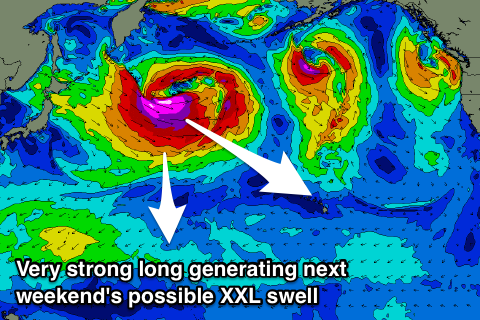
Of greater importance is an XL NW groundswell due next weekend, with a very intense low forecast to develop off Japan, projecting a great fetch of broadening severe-gale to storm-force W/NW winds towards us through mid-late next week.
AN XXL long-period NW groundswell will be generated for the Hawaiian Islands if all goes to plan, building with a bang Saturday and jumping rapidly to 20-25ft on the outer reefs and big wave spots. Winds look light and favourable at the moment, so will they pull the trigger on the Eddie Aikau event? We'll have to see how the storm pans out over the coming week.
North Shore Forecast Graph
North Shore WAMs
Micronesia: Large levels of N'ly groundswell should be easing across the region this morning with tricky winds, with a further drop due through tomorrow and Saturday, becoming small into next week.
Winds will ease off a little through tomorrow and tend more E/NE later, better into Saturday.
Through next week moderate amounts of E/NE trade-swell are due to build across the exposed east facing reefs but with poor conditions, while a new fun N'ly groundswell is due on Thursday.
This will be generated a small tight low spawning off Japan with a kick to the 4ft range due on Thursday.
Of greater importance is a larger swell due off the vigorous low spawning off Japan. This is due to arrive Sunday week and provide large 5-6ft sets with what looks to be favourable E/NE trades at this stage. More on this Tuesday.
Palikir Pass Forecast Graph
Palikir Pass WAMs
Papua New Guinea: Our good N'ly groundswell is due to peak tomorrow to an inconsitent 4-5ft+ across north swell magnets but conditions will be poor with a moderate to fresh NW breeze.
We'll see winds persist out of the W/NW through the weekend and early next week, finally easing later through the week.
The trade-swell will be small by then with 2ft+ waves across magnets, while fun N'ly groundswell pulses should be seen Friday and Monday the 14th respectively. The first for Friday looks minimal and to 3ft, with Monday's better and to 3-4ft+, but more on this Tuesday.