Slight upgrade in W/NW groundswell next week

Hawaii North Shore, Micronesia and PNG forecast by Craig Brokensha (issued on Thursday 2nd March)
Best Days: North Shore magnets Sunday onwards, and N'ly friendly breaks from Tuesday, though with NE trades - Micronesia: Later Tuesday through Thursday next week - PNG: Every day
This week and next (Mar 2 - 9)
Hawaii: Small surf is continuing across the region and we'll see this trend hold through until the weekend when some new long-range NW groundswell should fill in.
This swell and a secondary pulse for later Tuesday/Wednesday are being generated by distant lows spawning off Hawaii.
The first pulse for later Saturday and Sunday isn't expected to top 3ft across North Shore swell magnets, while the secondary pulse has been upgraded a bit, with a better fetch of severe-gale W/NW winds being aimed towards us.
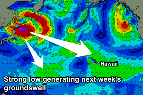 The long-period energy should arrive later Tuesday and kick to 4-6ft at swell magnets, easing back from 4-5ft Wednesday morning.
The low spawning south-west of Alaska is now expected to sit more north-northeast of us, but project southwards, generating a large N/NE tending NE groundswell for later Tuesday and Wednesday as well.
We should see exposed breaks to the north swell coming in at 6-8ft on Wednesday, easing off into Thursday, while a secondary intensification in our swell window should generate a secondary NE pulse to 6ft+ Thursday afternoon and Friday morning.
Winds for this swell event won't be too favourable with gusty E/NE trades Monday due to swing more NE with the peak of the swells Tuesday through Thursday.
North Shore Forecast Graph
North Shore WAMs
Micronesia: We've got some E/NE trade-swell currrently on the build, with it due to reach 3ft in protected spots out of the trades tomorrow and Saturday before starting to ease slowly from Sunday/Monday.
With the upgrade in the strength of the low off Japan, we're now due to see some better N/NW groundswell for next week, arriving later Tuesday and kicking to 2-3ft on dark, with infrequent 2-3ft+ waves on Wednesday.
We'll then likely see the swell ease off into the end the week.
Palikir Pass Forecast Graph
Palikir Pass WAMs
Papua New Guinea: Small levels of fun NE trade-swell should persist over the coming days to 3ft on the sets, increasing a little through early next week to the 4ft range. Light variable winds will create great conditions each morning, with afternoon sea breezes.
The swell is due to ease a touch into the end of the week, more pronounced down through next weekend.