Stormy N/NW swell to end the week, good inconsistent swell Sunday afternoon

Hawaii North Shore forecast by Craig Brokensha (issued Thursday 15th December)
Best Days: North Shore early Thursday morning, Sunday afternoon, Monday, Wednesday, Micronesia Friday and Saturday, PNG from Wednesday
This week and next (Dec 16 - 23)
Hawaii: Not the best conditions yesterday with N/NE winds and an inconsistent easing NW groundswell, while today a good N/NE swell has filled in with better E/NE trades and funky waves across the North Shore. Not classic North Shore conditions.
 We should see the N/NE swell peaking this evening and then easing back from 5-6ft at spots exposed to the north swell tomorrow with early light variable winds. A strengthening NW'ly through the day will create poor conditions.
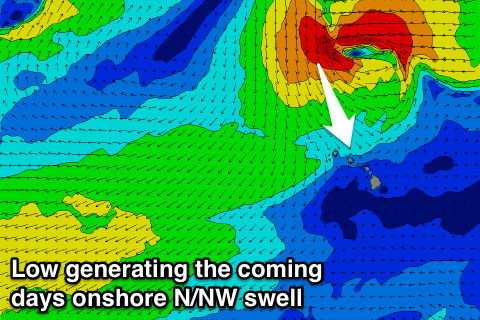
This unseasonal wind will be linked to a deepening surface trough come cut-off low to our north, projecting a fetch of strong to gale-force N/NW winds towards and then into us over the coming couple of days.
With this we'll see a large raw and stormy N/NW swell building through Friday and peaking overnight.
The North Shore should build from the 6ft range at dawn Friday to 10-12ft into the afternoon, easing from a similar size Saturday morning.
Conditions will be a mess though as the low pushes into the islands, generating fresh W/NW tending W/SW winds Friday and then gusty W/SW tending SW winds Saturday.
Sunday should become cleaner but not perfect with a further drop in swell under S/SE winds.
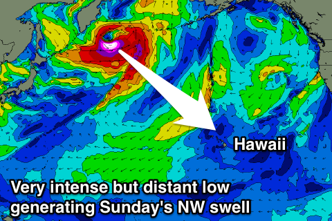 Into the afternoon though a new long-period and inconsistent NW groundswell is due, generated by a very strong but distant low that's currently developing off the Kamchatka Peninsula.
A fetch of storm to near hurricane-force W'ly winds will be produced, but only for a short period in our swell window.
As a result only an inconsistent moderate sized NW groundswell is due, arriving early Sunday morning and peaking later in the day to 6-8ft across the North Shore, and then easing off steadily from the 5-6ft range Monday morning.
E'ly trade winds should kick in again later Monday, with SE winds through the morning.
Into next week only small to moderate amounts of distant NW groundswell are on the cards from unconsolidated storms north-west of us. E'ly trades will kick back in creating decent conditions but there's no major swells showing as of yet.
North Shore Forecast Graph
North Shore WAMs
Micronesia: There's been no real change to the outlook since Tuesday with moderate to large levels of E/NE trade-swell expected to build across east facing breaks today and further into the weekend.
Solid 4-5ft+ waves are due tomorrow, with sets further to 6ft Saturday and Sunday, easing back a touch into next week.
The swell is expected to persist all next week before easing of later Friday.
Unfortunately locations seeing this swell will be poor with fresh to strong E/NE trades.
Also in the mix tomorrow and Saturday should be an inconsistent N'ly groundswell from the low off Japan earlier this week. Infrequent 3ft sets are due from this swell.
Palikir Pass Forecast Graph
Palikir Pass WAMs
Papua New Guinea: From this afternoon we should see the trade-swell building out of the north-east, reaching 3-4ft+ into the afternoon on Saturday, with a secondary pulse to 3-5ft early next week before easing off slightly mid-week.
The swell should muscle up again late week from another burst of trades, holding through Saturday.
Our unfavourable W'ly winds are still due to strengthen from Saturday afternoon, but we should see them become variable again from Wednesday creating excellent conditions.