Easing surf ahead of a good N/NW groundswell Friday, N/NE swell early next week

Hawaii North Shore forecast by Craig Brokensha (issued Tuesday 15th November)
Best Days: North Shore, Tuesday, Wednesday, Friday more protected breaks, Saturday morning, Monday
This week and next week (Nov 11 - 18)
Hawaii: Friday's XL swell peaked through the day and eased off through the weekend, slowed slightly by a reinforcing N/NW pulse Saturday afternoon.
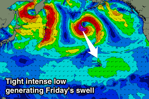
Today though another very large NW XL swell is impacting the Hawaiian Islands with only a select few breaks and outer reefs handling the size.
The swell has peaked and from here we'll see a steady downwards trend, easing back from the 8ft range tomorrow morning, smaller into Wednesday and more around 4-5ft. Thursday should then become even smaller.
 Fresh to strong E/NE trades are expected over the coming week, tending less favourably to the NE Friday as a new moderate to large sized N/NW groundswell fills in.
This swell will be generated by a short-lived but intense low firing up north-northwest of us, aiming a tight fetch of severe-gale to near storm-force N/NW winds temporarily in our swell window before tracking off to the east.
The swell should fill in Friday and peak through the day to 6-8ft across exposed breaks, if not for the odd bigger bomb, easing back into the weekend.
From here on a couple of stubborn blocking highs will sit across our main swell windows, resulting in no significant swells from the north-west.
A funky N/NE groundswell is due Monday next week though, generated by a the remnants of the low producing Friday's swell, stalling south of Alaska, aiming a fetch of severe-gale N/NW winds towards Baja Mexico, with some N/NE swell spreading out radially towards us.
Exposed spots to the N/NE swell should see 6ft sets, bigger at islands further east of Oahu.
Longer term there's nothing too major on the cards for us, so make the most of the current swell.
North Shore Forecast Graph
North Shore WAMs
Micronesia: Today a pulse of inconsistent N'ly groundswell should be impacting the islands, generated by a low forming off Japan last week.
This swell should ease off through tomorrow and we'll be relying on small to moderate levels of E/NE trade-swell for the rest of the period.
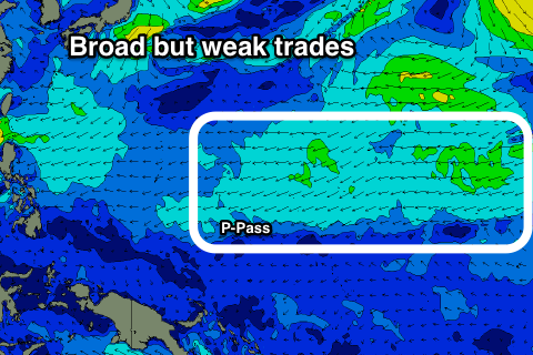
A broad and persistent but relatively weak fetch of E/NE trades are expected to move slowly west over the coming week and this should kick up plenty of swell for us.
Spots open to the east should build to an easy 3-4ft into the end of the week, with larger sets possible Sunday at the peak of the swell, before easing back into early next week.
 We should also see some N/NE swell in the mix mid-next week from a fetch of strong N/NE winds in our swell window over the weekend. This looks to again come in around 3-4ft.
Winds over the coming period won't be ideal for locations picking up the easterly trade-swell with fresh E/NE trades tomorrow, strengthening into the end of the week and persisting over the weekend before abating into next week.
Palikir Pass Forecast Graph
Palikir Pass WAMs
Papua New Guinea: The outlook for the region isn't too exciting, with a very inconsistent and small N'ly groundswell due to show this afternoon with 3ft sets at magnets, easing off into tomorrow and further Friday.
The NE trade-swell should start showing over the weekend with small 2ft sets, stronger early next week more to 2-3ft or so before easing from Wednesday. Variable winds should keep conditions clean each morning.