XL swell easing tomorrow with another very large swell late week

Hawaii North Shore forecast by Craig Brokensha (issued Tuesday 8th November)
Best Days: Experienced surfers North Shore through the coming week, exposed breaks Micronesia Friday through early next week, PNG swell magnets over the period
This week and next week (Nov 9 - 18)
 Hawaii: We've seen the XL N/NW groundswell due across the islands fill in this afternoon with the Waimea buoy showing fore-runners to 22s, settling back to 18-20s this afternoon. The swell has also jumped significantly to 14ft (below), resulting in XL surf across the North Shore this evening.
The 51101 buoy situated further to the north-west of the Hawaiian Islands peaked late morning and with an approximate travel time of 10 hours, we'll likely see the swell peak this evening.
Due to the longevity of the storm generating the XL swell though, tomorrow is expected to still reveal XL surf, easing from the 15ft+ range on the sets, down steadily through the day, further from the 8ft to possibly 10ft range Wednesday morning. Gusty NE winds today are expected to ease back to a fresh E/NE'ly tomorrow and then lighter Wednesday morning.
Into Thursday a moderate sized N/NW groundswell is due for the morning, ahead of another very large N/NW groundswell later in the day, easing Friday.
The swell for the morning will be produced by a small tight embedded low at the head of a much more significant fetch of gale to severe-gale W/NW tending NW winds projecting towards us over the coming two days.
A new mid-period N/NW swell to 6ft is expected Thursday morning, with the long-period and large N/NW groundswell from them fetch proper arriving later Thursday afternoon and kicking to an easy 12-15ft by dark again.
After an overnight peak, we should see the swell ease from the 15ft range Friday morning, possibly the odd bigger bomb early, down further from 8ft or so Saturday.
Weak E/NE trades should create clean conditions through the mornings with a little more north in the wind through the afternoons.
The surf will continue to ease into Sunday, but yet another large groundswell is expected early next week, but this will have more west in it, generated initially off Japan before the storm has a second intensification north of us over the weekend.
This large long-period NW groundswell should arrive overnight Sunday and peak through the day Monday to an inconsistent 10-12ft with the possibility for the odd bigger one.
For the rest of the week there's nothing significant due with a gradual easing trend under strong E/NE trades, small to tiny into the end of the week.
North Shore Forecast Graph
North Shore WAMs
 Micronesia: Small amounts of E/NE trade-swell are breaking across eastern shores with sets in the 3ft range, and this should hold tomorrow before easing off very slowly into the rest of the week and weekend.
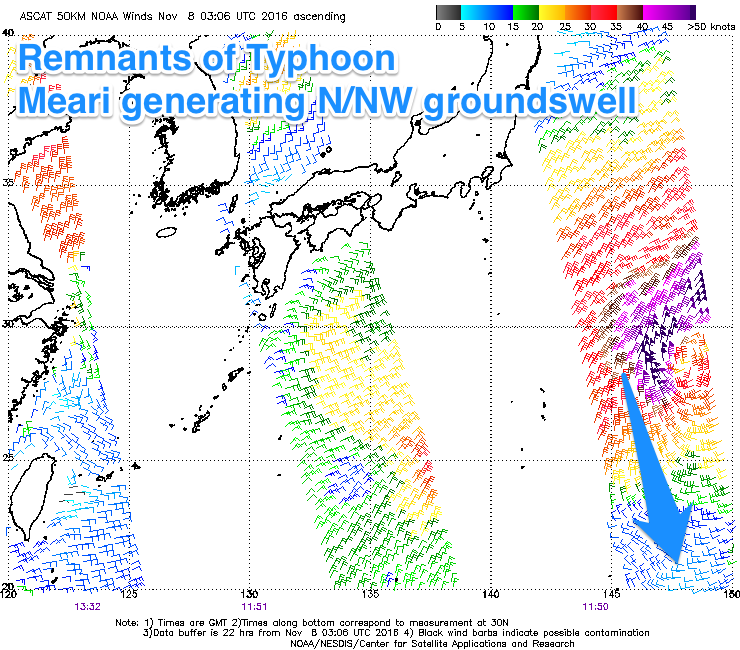
Some fun N/NW groundswell is expected Thursday afternoon, peaking Friday morning from the remnants of Typhoon Meari. This system is currently south-east of Japan, generating a right fetch of gale to severe-gale N'ly winds while tracking away from our swell window.
Still we should see good sets to 4-5ft Friday morning, before easing back into the afternoon and further over the weekend. Funky SE winds will also ease off from Friday with weak E'ly trades from then on.
The low forming off Japan, generating Hawaii's large NW groundswell will track a little too quick through our swell window to generate any major size, with an inconsistent 3-4ft+ of N'ly groundswell due to fill in Monday, easing Tuesday. From then on there's no major trade-swell or groundswell due, so make the most of the coming small periods of surf.
Palikir Pass Forecast Graph
Palikir Pass WAMs
Papua New Guinea: Some small and inconsistent E/NE trade-swell should be breaking across magnets to an infrequent 3ft on the sets, holding tomorrow morning before easing off into the end of the week to a smaller 2ft+.
The N/NW groundswell impacting Micronesia Thursday/Friday will be inconsistent across PNG but should show Friday afternoon, reaching 3ft or so on the sets before easing off slowly from Saturday.
Light variable winds should create clean conditions, and longer term there's no significant surf due at all.