Easing XXL swell, new XXL swell for Thursday

Hawaii North Shore forecast by Craig Brokensha (issued Tuesday 23rd February)
Best Days: Experienced surfers only Tuesday, Wednesday, Friday, Saturday, Sunday
This week and next (Feb 23 – Mar 4)
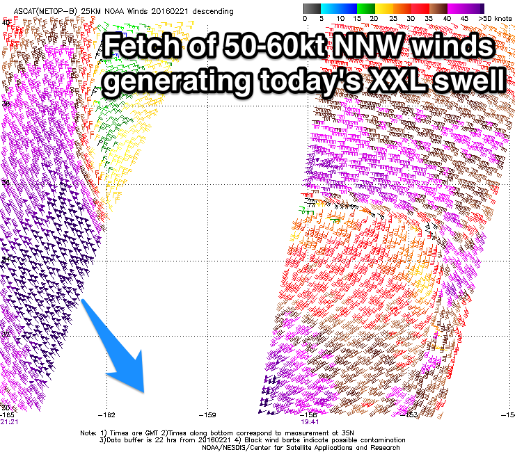 After a slow weekend, later in the day Sunday some new NW groundswell started to show, but today we've seen an enormous new N/NW groundswell impacting the islands, upgraded significantly from last Thursday. This is due to the front pushing down towards us the last couple of days being much stronger than forecast last week, with a fetch of storm-force 50-60kt N/NW winds being projected just north of Hawaii (right).
Our models accordingly adjusted for the stronger low, upping the forecast to the 30-35ft range across the North Shore this afternoon, and the real time buoy readings seem to be in line with this. The Waimea buoy is showing peak wave heights of 28ft, that's 8.5m of groundswell at 14.5 seconds.
Conditions are a mess though with the large consistent nature of the swell and a fresh N'ly wind.
The swell has started to dip on the 51101 buoy about 10 hours travel time to the north-west and with this we can expect today's huge swell to ease back through tomorrow, likely from the 18-20ft+ range. Conditions will be much cleaner as well with light offshores and weak sea breezes.
Wednesday should remain clean through the morning as the swell continues to ease back from the 10ft range.
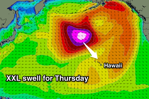 Now, heading into Thursday we've got another huge XXL swell on the cards, but this one will exhibit much stronger peak periods.
Currently a broad and elongated fetch of severe-gale to storm-force W/NW winds have formed south-east of the Kamchatka Peninsula.
The low generating this fetch is forecast to project slowly south-east towards Hawaii while maintaining its intensity and moving at a similar speed to the swell that it's generating before stalling north of the islands ahead of one final push south. Open ocean swell heights will grow faster than normal under this scenario.
A long-period XXL swell should result, with the fore-runners arriving through Wednesday afternoon ahead with the bulk of the size arriving overnight and peaking Thursday morning across the North Shore.
We're looking at large 25-30ft waves across the North Shore, with bigger sets at deep water offshore reefs, easing back a touch into the afternoon and more so into Friday from 20ft+ range.
The only issue are local winds and they look less than ideal with moderate to fresh NE breezes Thursday, swinging more E/NE through the day while strengthening. This may be the fly in the ointment regarding the green light being given for the Eddie or not.
Friday looks great with morning offshores and afternoon sea breezes, and E/NE-NE trades into Saturday as the swell continues to ease.
Into Sunday a new moderate to large sized NW groundswell is likely from a strong frontal system pushing down on a similar path the the storm generating Thursday's swell, but behind this we may see a better XL swell producer for early next week. We'll have a closer look at this Thursday though.
Comments
These buoy readings off Waimea have to be seen...
I had only just emailed this to a few mates, crazy big. easily the biggest I have seen this buoy this year
8.5@14.5 is pretty big eh . But no bigger than the southern ocean gets .Thanks Craig
True, but there's no continental shelf in Hawaii so hits so much larger and bigger.
Bbbbbbut they said its as powerful as hawaii here !
Didn't mention power above :) Although waves in Hawaii move much faster then here I hear.
Your selling ice to an eskimo craig . I disapprove of continental shelfs
Hahaha, sorry missed the sarcasm :p
Yeah pffft .... 14 sec's that's just a local wind swell . This next swell will surprise a few . Should build quicker due to residual alongside the captured fetch scenario you guys pointed out . Lemon - pie anyone ?
We did see 8m @18 on the sorrell buoy 18 months ago .
Southeys in form remember , lets see if hes nailed this next one
Potential brock /Eddie forecast is decent
Enough already!
Southey, this next swell for Thursday doesn't seem to be any bigger than anything seen this season already for me. It will be smaller than today, longer period but smaller at its peak.
regardless of how big yesterdays event was . it wasn't a swell as it was unridable . pure and simple . as you guys wrote in the eddie piece it was contaminated with the low extending down too close . i would suspect however that there will be epic waves for a few days alot further south of Hawaii . Even as far south as some central/eastern Sth pacific spots . Was a very Nth aligned swell .
As for saying it will be smaller . i doubt it, wave faces should be bigger . Theres a big difference between 18 seconds and 14 . you've said yourself as much that larger periods get concentrated on the Hawaiin Islands . the only difference being is that this smaller period swell was much closer to due Nth .
Doesn't look pretty for the bay with the noreaster blowing & big period refracting into the bay does it ?
No, and winds are looking fresher now through the morning, bugger.
Did the swell get over 8.5@14.5 ?