Small waves ahead of larger swells from Thursday

Hawaii North Shore forecast by Craig Brokensha (issued Mon 16th December)
Best Days: Every day over the coming period
 This week and weekend (Feb 17 - 22)
A large increase in N/NW groundswell seen through yesterday is easing steadily today with light winds creating clean conditions across most breaks.
We'll continue to see the swell drop through tomorrow under favourable E/SE trades from 3-5ft early, becoming very small into the afternoon.
Wednesday will be a lay day with small to tiny surf as favourable winds continue.
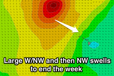
Into Thursday and Friday a strong and large W/NW groundswell is expected to fill in across the North Shore, generated by a strong and powerful low pressure system that's formed off Japan, aiming a fetch of gale to severe-gale W/NW winds towards us.
An initial increase in W/NW groundswell through Thursday will be very acute in direction, with breaks that like west swells due to build to 10ft+ later in the day and peak Friday morning either side of 12ft.
A secondary similar sized and reinforcing NW groundswell is due through the evening Friday though, peaking Saturday morning, generated by the same storm, generating an additional fetch of NW gales aimed towards us.
Size wise we should continue to see 12ft waves through Friday afternoon 12-15ft sets early Saturday morning ahead of a steady easing trend through the afternoon, further Sunday and into early next week.
Winds will unfortunately be poor and strengthening from the S/SW Thursday and then SW to NW Friday while Saturday should improve slightly as winds tend NE. From Sunday favourable E'ly trades will kick back in as the swell gradually drops away.