Large surf with light winds to continue

Hawaii North Shore forecast by Craig Brokensha (issued Wed 14th December)
Best Days: Every day over the coming period for experienced surfers
This week and weekend (Jan 15 - 18)
An easing W/NW swell with light to moderate S'ly winds is being seen today, and we should see the swell bottom out overnight and into early tomorrow morning.
A strong and large W/NW groundswell is due to fill in through the day though, the second in a series of three large pulses due this week/weekend all owing to a broad Aleutian Low stall to our north-west.
Tomorrow's swell should come in larger than yesterday's with exposed breaks on the North Shore hitting 10-12ft into the evening. A peak is due overnight before the swell drops only temporarily and slightly through Friday.
We may see a late kick in new large W/NW groundswell Friday evening, but Saturday should reveal the most size with the largest of the groundswells peaking, offering 10-12ft+ waves across the North Shore and larger 15ft sets at offshore deepwater reefs.
From here on wave heights are expected to ease steadily through Sunday and Monday, bottoming out Monday evening.
Conditions will remain favourable for most of the period with generally variable winds form the S'th over the coming days, tending a touch more E'ly through the weekend.
 Next week onwards (Jan 19 onwards)
Monday evening's low point in swell activity will be short-lived as we're expected to see a new moderate-large W/NW groundswell arriving through the day and peaking into the afternoon/evening.
This swell will be generated by a small but intense low forming just east of Japan, tracking east while aiming a fetch of severe-gale to storm-force W/NW winds towards Hawaii.
An good long-period W/NW groundswell should result, peaking Tuesday evening in the around the 8ft range.
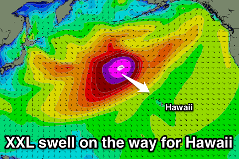
This swell will be superseded by a much more significant XXL swell on Wednesday which is discussed in greater detail in the linked article.
Beyond Wednesday's swell we should see large levels of NW groundswell persisting into the end of the week and weekend as a series of follow up storms push in right on the tail of the XXL swell producer, but with what appears to be average winds. More on this next Tuesday though.