Great December easterly swell

Eastern Tasmanian Surf Forecast by Craig Brokensha (issued Friday December 10th)
Best Days: Later Sunday, Monday, Tuesday
Features of the Forecast (tl;dr)
- Building S/SE windswell Sat with fresh S/SE winds, larger, stronger E swell building Sun with moderate SE tending lighter E winds
- Large, slow easing E swell Mon with variable tending N/NE winds, similar Tue as the swell continues to ease
Recap
Nothing of note the last two days with weak, tiny levels of windswell.
This weekend and next week (Dec 11 - 17)
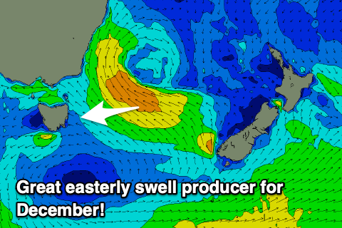 Currently a deep, intense low is sitting to our north-east with strong to gale-force SE winds aimed into the far southern NSW coast. This is out of our swell window but as we move into the weekend we'll see the low slipping south-east while broadening, opening up our coast to a great fetch of strong E/SE winds from tomorrow morning but mostly Saturday evening, then weakening slowly Sunday as the low breaks down.
We should see a moderate to large E'ly swell building Sunday with tomorrow consisting of mostly weak S/SE windswell under S/SE winds.
Sunday should kick to a good 5-6ft across open beaches into the afternoon, then easing slowly through Monday from a similar size.
Winds will remain onshore from the SE but weaken and be moderate, swinging more E/SE through the day and becoming lighter as the low weakens. The late session is then worth a look.
Into Monday variable winds are due in the morning, likely W'ly, shifting N/NE through the day and strengthening so northern corners will be the best.
A trough will move through Tuesday bringing variable winds again, E/NE into the afternoon as the swell weakens in size and power, dropping from 3-4ft.
For the rest of the week there's nothing significant on the cards besides a small N/NE windswell developing Friday so make the most of the coming surf! Have a great weekend.