Tiny to flat outlook with one possible flukey swell

Eastern Tasmania Surf Forecast by Craig Brokensha (issued Wednesday 21st July)
Best Days: No good days
Features of the Forecast (tl;dr)
- Small, inconsistent S'ly swell tomorrow but only to 1-2ft max on the south magnets with W/NW tending NW winds
- Flukey E/NE swell possible for Mon/Tue with W tending NW winds on Mon and stronger N/NW winds Tue
Recap
A late increase in weak S'ly windswell yesterday afternoon, with some small, clean waves leftover into this morning across the south magnets.
This week and weekend (Jul 22 - 25)
The swell generated by yesterday's strong change will likely be all but gone tomorrow with only the odd stray 1-2ft set across the south swell magnets for the patient and desperate.
Unfortunately, as mentioned in Monday's update we're looking at a poor run of surf for the coming week or two as the westerly storm track kicks into gear, projecting mid-latitude fronts across us.
They'll be tracking too far north to generate any real south swell.
 Looking to our north and pre-frontal N/NW-NW winds will be just that, not ideally aimed at all to generate any size from the north, even though the models show small spikes in energy.
So maybe try the South Arm over the coming days for a wave before they too become wave starved.
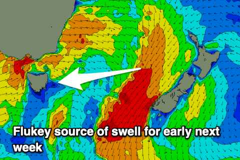
Before you leave, there's one flukey swell source for Monday and Tuesday, that being strong to gale-force though poorly aimed NE winds strengthening west of New Zealand on Sunday but any swell off this looks dicey and only to 2ft or so. We'll have one more, closer look at this on Friday.