Good run of surf continues

Eastern Tasmania Surf Forecast by Craig Brokensha (issued Monday 5th July)
Best Days: Every day besides Friday
Features of the Forecast (tl;dr)
Recap
- Building NE swell tomorrow PM, easing slowly Wed and Thu
- Building S swell tomorrow PM, easing Wed, with a smaller pulse Thu
- W/SW tending S winds tomorrow, W/SW tending S/SE on Wed and W tending variable Thu
- Building NE swell Sat, peaking out of the E/NE Sun
This week and weekend (Jul 6 - 11)
 We've got one more final pulse of NE swell for the state due tomorrow afternoon, with the final burst of strong to gale-force NE winds embedded in a trough line that's zippering down the Tasman Sea being generated last night and this morning.
Size wise, tomorrow morning should ease a touch from today with sets coming in at a less frequent 4ft across the regional swell magnets, kicking a touch through the afternoon, then easing from 3-4ft on Wednesday, down further from 2-3ft Thursday.
Also in the mix tomorrow afternoon and Wednesday should be some mid-period S'ly swell front a polar front pushing up and past us during the day.
South facing beaches should build to 3ft late in the day tomorrow, easing from the 3ft range Wednesday.
A secondary weaker front should generate a small 2ft of swell Thursday as the E/NE energy fades.
 Coming back to the winds and a morning W wind will shift S'ly late morning tomorrow, W/SW tending S/SE on Wednesday and then W'ly tending variable Thursday.
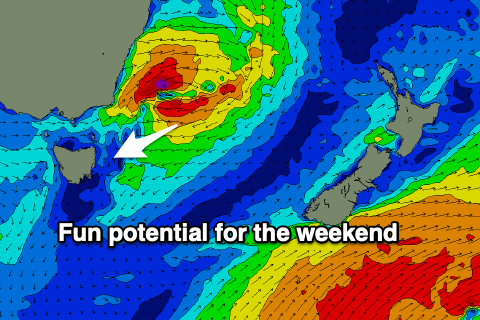
Friday looks a bit funky with variable tending SE winds as a surface trough to our north-east deepens into another low.
This looks to aim a short-lived fetch of strong to gale-force E/NE winds through our swell window, kicking up a pulse of NE swell for the weekend. The swell should build Saturday, reaching 2-3ft by dark, peaking Sunday morning with sets to 3-4ft along with offshore winds.
More on this and the possibility of some fun SE swell next week on Wednesday.