Fun N/NE swell followed by large S'ly swell

Eastern Tasmania Surf Forecast by Craig Brokensha (issued Wednesday 8th January)
Best Days: Later Friday, Sunday and Monday for experienced surfers, Tuesday
Recap
A small mix of leftover S'ly swell and N/NE swell yesterday to 1-2ft, holding 1-2ft today out of the NE.
This week and weekend (Jan 9 - 12)
The surface trough responsible for the current run of small NE swell was still sitting north-east of us today, generating a weak fetch of E/NE winds.
This should keep the coast around 1ft to occasionally 2ft tomorrow ahead of a building N/NE windswell Friday as winds strengthen off our coast.
 Building surf to 2-3ft is expected through the day if not there at dawn across north-east swell magnets on Friday, and looking at the winds an early light N/NW breeze is due tomorrow ahead of fresh N/NE wind, fresh to strong N/NE Friday ahead of a late afternoon W/NW change, W/SW into the evening. This will be the time to surf. Saturday looks clean but tiny.
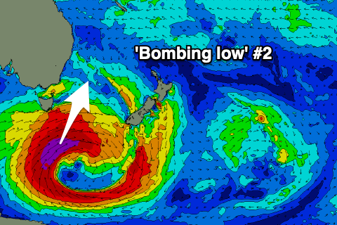
We've now got an upgrade in the S'ly swell due from Sunday, with a 'bombing low' now forecast to again form in our swell window this weekend.
We'll see this low forming south-west of the state on Friday evening, with a better aligned (compared to last weekend) and slow moving fetch of severe-gale to storm-force SW-S/SW winds due to form in our southern swell window.
This will generate a large, long-period S'ly groundswell, with an initial pulse for Sunday and secondary pulse for Monday.
Size wise at this stage we're looking at surf building to 6ft to possibly 8ft across south swell magnets with favourable winds Sunday, holding the 6ft range Monday with N'ly winds. We'll dial down the specifics Friday.
The easing trend will be slow owing to the slow movement of the low, with plenty more swell out of the east on the cards from later week.