Tiny to flat with potential next week

Eastern Tasmania Surf Forecast by Craig Brokensha (issued Friday 15th November)
Best Days: No good days until later next week
Recap
The flukey southerly swell yesterday failed to really materialise, with today tiny as expected.
This weekend and next week (Nov 16 - 22)
There's nothing of significance due over the weekend, with frontal activity moving in from the west, being just that.. too west.
 A weak and better angled fetch of SW winds projecting up past us through Sunday may generate a weak 1-2ft of S'ly swell through the afternoon across south facing beaches but with NE sea breezes.
Monday will be cleaner but the swell gone.
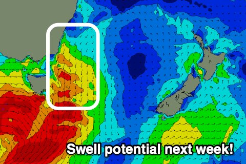
We've got a better swell source on the cards for later in the week.
A strengthening mid-latitude storm dipping south-east across the state will squeeze against a strong high in the Tasman, hence the deflection, with a fetch of strong to gale-force N/NE winds due to develop in our swell window Thursday, pushed offshore at some stage during the afternoon.
It's hard to put a size on the N/NE windswell at this stage, but we're looking at surf around 3ft+. Check back here on Monday for a clearer idea on the timing, size and local winds for this swell.