More S'ly swell, with a downgrade in N/NE swell

Eastern Tasmania Surf Forecast by Craig Brokensha (issued Wednesday 2nd October)
Best Days: Thursday and later Saturday south swell magnets
Recap
Easing S'ly swell from a good 2-3ft across south swell magnets, tiny today. A new S'ly groundswell is due late today, but tomorrow will be the pick as it peaks.
This week and weekend (Oct 3 - 6)
A strong polar low moving through our southern swell window the last couple of days has generated a good S'ly groundswell that may be seen later today but will peak tomorrow morning, easing off through the day.
3ft sets are due across the south swell magnets tomorrow morning and a W/NW wind will create clean conditions ahead of fresh N/NE sea breezes.
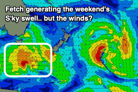 No size is expected to be left into Friday morning, while we've got an upgrade in the S'ly swell due on Saturday as a strengthening polar front clips the south-east corner of the state.
A fetch of strong to near gale-force SW winds will generate a fun S'ly swell that should kick back to 3ft across south swell magnets Saturday, easing back from 1-2ft Sunday.
Winds on Saturday still look average and S/SE in the wake of the front in the morning, swinging E/NE through the day and then NE later, so there might be options for the keen late.
The windswell event for Sunday now looks a little smaller, with a brief burst of strong N/NE winds due through our swell window Sunday morning, kicking up a 2ft of swell into the afternoon and a NW change looks to be right on dark rather than earlier.
This will also kill off the swell overnight with fading 1ft waves with offshore winds Monday.
Longer term we've got some fun S'ly swell for next week, but more on this Friday.