Large, windy and wet weekend

Eastern Tasmania Surf Forecast by Craig Brokensha (issued Friday 6th September)
Best Days: Protected spots tomorrow, Sunday, protected spots Monday
Recap
Small fun levels of E/NE swell yesterday, dropping today and poor with strengthening onshore winds.
Today’s Forecaster Notes are brought to you by Rip Curl
This weekend and next week (Sep 7 - 13)
An intense and cold mid-latitude low is currently moving in from the west while deepening and over the coming days we'll see large and windy surf developing across the coast, biggest tomorrow afternoon.
Currently a slim fetch of strong to gale-force NE-E/NE winds are being aimed at us, with this fetch slipping away to the south-east tomorrow morning.
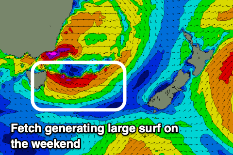 This will limit the swell expected out of the E/NE, but come tomorrow morning, the southern flank of the low will project a fetch of E/SE gales right into us, producing a rapid increase in stormy E/SE swell.
Size wise, tomorrow morning looks to be around the 4ft range and with strong S/SE winds and torrential rain, creating poor conditions.
The swell is due to build rapidly to a stormy 6-8ft into the late afternoon but with persistent strong S/SE winds.
The low will start to push north through Saturday evening and Sunday, resulting in local winds easing and the swell easing from a large 6ft+ across open beaches.
Winds will swing more S/SW-SW, creating cleaner conditions with afternoon N/NE sea breezes on the cards.
The swell will drop more steadily Monday from the 4ft range across open beaches, but another strong front pushing up and past us will bring a new mid-period S'ly swell. Size wise there isn't expected to be much power to it, with south facing beaches building to the 4ft range with strong S/SW tending S'ly winds.
Tuesday will be much cleaner with a W/NW offshore ahead of NE sea breezes and small easing S'ly sets from 2ft+ at south magnets.
Longer term, a small fetch of E'ly winds off New Zealand may generate a small pulse of E'ly swell for Thursday morning, but we look to other possible developments later in the week and into next weekend.
The models diverge on the possibility of a couple of strong mid-latitude lows pushing up past us, so check back here Monday for the latest. Have a great weekend!
Comments
What makes you say winds will be S - SW Sunday morning ?