Saturday is the day

Eastern Tasmania Surf Forecast by Craig Brokensha (issued Friday 5th April)
Best Days: Saturday
Recap
A small leftover S'ly windswell yesterday with better than expected morning conditions, while today a N/NE windswell has started to build. Small and weak this morning but we should see things starting to really kick up later today.
Today’s Forecaster Notes are brought to you by Rip Curl
This weekend and next week (Apr 6 - 12)
Our solid N/NE windswell event for tomorrow is still on track, though with the strength of the associated winds, we'll be looking at more of a drawn out mid-period swell event.
Currently a strong cold front is pushing in from the west, squeezing a high in the Tasman Sea resulting in a great strengthening fetch of strong to near gale-force N/NE winds through our swell window, reaching a peak in intensity early tomorrow morning.
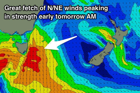 This is ideal for us seeing the most size in the daylight hours, with north-east facing beaches due to see 4-5ft waves tomorrow morning, if not for the odd 6ft bomb, easing rapidly through the day as a W'ly change moves through.
At dawn winds may still be gusty out of the N/NW, but they'll quickly shift NW-W/NW through the morning ahead of a S/SE change into the afternoon, favouring these north-east swell magnets even more as the swell eases.
Sunday looks to be small to tiny with no size left at all under a NW offshore. Therefore make the most of tomorrow.
Unfortunately the low that was forecast to form over near New Zealand isn't on the cards any more and we'll see the surf become tiny into next week, with no size out of the E/NE at all.
A weak front pushing up past us on Tuesday may generate a small S'ly swell for Wednesday to 2ft to maybe 3ft, but we'll review this Monday.
Longer term there's nothing significant on the cards unfortunately, so all systems are go to maximise the surf tomorrow. Have a great weekend!