Good surf tomorrow, a little limited into Wednesday and Thursday

Eastern Tasmania Surf Forecast by Craig Brokensha (issued Monday 14th November)
Best Days: Tuesday, Wednesday in southern corners, Thursday morning south swell magnets
Recap
A tiny start to the weekend before strong onshore winds and large levels of building storm surf from the E/NE were seen.
Sunday dawned lumpy and large with 5-6ft sets across the Upper East Coast under a light NW breeze. Further south of the lows axis though, strong onshore winds continued to create poor conditions, slipping back up north around midday.
Today with the low moving off to the east, S/SE winds were seen wrapping around its western flank, with large easing sets from 4-6ft. Southern corners were the pick for a wave.
This week (Nov 15 - 18)
The low responsible for the current E'ly swell has transformed in structure, with a fetch of strong SE to E/SE winds spanning from our coast to New Zealand's South Island during today.
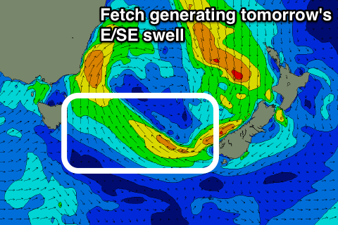 This fetch will persist into early this evening before swinging away from us overnight.
What we can expect is easing levels of moderate sized E/SE swell from 3-4ft tomorrow morning, fading from 2ft Wednesday morning.
Some new S'ly swell is on the cards for Wednesday though from a front pushing up and past us tomorrow afternoon and evening.
A broad fetch of strong to gale-force S/SW winds should kick up 3ft of S'ly swell for south facing beaches Wednesday, easing back from 2ft+ or so Thursday morning.
Conditions tomorrow look good with a W/NW tending variable breeze but Wednesday will then see SW tending E/SE winds. Thursday should be better at south facing breaks again with a N/NW'ly.
Besides a small N/NE windswell into the end of the week there's nothing major on the cards, so make the most of the coming days waves.