Slowly easing E'ly swell with good S'ly groundswell pulses

Eastern Tasmania Surf Forecast by Craig Brokensha (issued Friday 25th March)
Best Days: Every day over the coming period until Wednesday
Recap
A good new E/NE swell started to build across the coast yesterday morning with clean 2-3ft waves, building to a stronger 3-4ft into the afternoon. This morning the swell is hanging in at a great 3-4ft with offshore winds.
This weekend and next week (Mar 26 – Apr 1)
The E'ly swell will start to ease off through the weekend and further into next week with offshore winds each morning.
Open beaches are due to still offer infrequent 3ft sets tomorrow morning, smaller Sunday from the 2ft+ rangr with 1-2ft leftovers Monday.
From later tomorrow afternoon but more so Sunday and Monday some good S'ly groundswell is due.
Tomorrow's pulse has been generated by a post-frontal fetch of SW gales through our swell window yesterday, with south facing beaches due to reach 2-3ft later in the day.
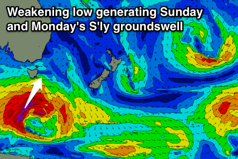 Of greater significance is an intense mid-latitude low moving in from the west today and tomorrow, generating a fetch of weakening severe-gale to storm-force W/SW winds through our swell window.
This low won't be perfectly aligned, but some good S'ly groundswell should spread radially back up and into us through Sunday peaking through the middle of the day/afternoon to a good but inconsistent 3-4ft across south swell magnets, easing back slowly through Monday from a similar 3ft+ from fetches off the backside of the low and weaker trailing polar frontal activity.
This trailing frontal activity should keep 2ft+ sets hitting south facing beaches before fading away Wednesday.
Conditions are looking great each morning with offshore winds until things get a little funky Wednesday.
Longer term besides some small E/NE swell later week and a small refracted S'ly groundswell there's nothing major on the cards, so make the most of the coming swell. Have a great weekend!