Building E/NE swell, peaking late week

Eastern Tasmania Surf Forecast by Guy Dixon (issued Monday 21st March)
Best Days: Tuesday, Thursday and Friday mornings.
Recap:
There was no shortage of southerly swell over the swell, with options holding in the 4-6ft range, firstly short-range energy on Saturday, then more substantial groundswell on Sunday. Early southwesterly breezes kept conditions clean, before tending more southerly each day.
The surf has eased back to around 3-4ft today, with only a brief window of decent winds earlier this morning. South/southeasterly breezes are now having an impact on quality.
This week (Tuesday 22nd - Friday 25th):
Southerly energy will continue to fade throughout Tuesday, slowed only by a weak fetch extending from the southern tip of New Zealand’s South Island towards the mainland.
This fetch is fairly modest in strength and not perfectly aligned to Tasmania, but should maintain a small amount of energy, slowing the easing trend from the 2ft+ range. By Wednesday, we should be seeing the last of this energy, fading from 1-2ft.
Tuesday should be OK with a variable tending light SW wind, increasing form the northeast later. Wednesday looks better, with northwesterlies on the cards until at least midday.
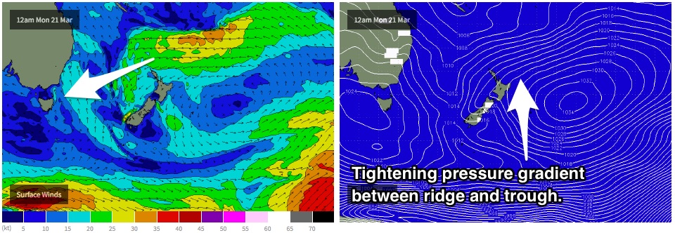
Meanwhile however, we can expect the surf to increase across open beaches as the effects of an intensifying trade flow fill in. A strong ridge over to the east of New Zealand has been interacting with a trough to the north steering a broad, stationary and well aligned easterly fetch, limited only by the swell shadow of far northern parts of the North Island.
As a result, the surf will gradually build in the days to come, with swell periods steadily increasing each day to a peak late in the week.
This swell is then due to peak late on Thursday as a result of a slight intensification and retrograding motion of the fetch with sets in the 3ft range. Exposed beaches and swell magnets have the potential to see the odd bigger bomb, fading from a similar size range from early Friday morning.
Thursday is looking at light westerly breezes during the morning, increasing and holding from the west during Friday as a front passes to the south.
This weekend (Saturday 26th - Sunday 27th):
Meanwhile, poorly aligned fronts throughout the week have been stirring up the Southern Ocean, priming the sea state for a series of fronts which look to produce groundswell for the magnets over the weekend.
As trade energy slowly fades, pulses of southerly energy look to fill in across south facing beaches. Initially, we should see a decent pulse generated by a strong system deep in the Southern Ocean.
Although there is likely to be an element of westerly component in this swell, exposed spots should still see sets in the 3ft range on Saturday morning, with a secondary pulse holding a similar size on Sunday.
Early offshores are on the cards for Saturday, becoming seabreezey during the afternoon. Sunday on the other hand should see northwesterly breezes dominate once again as a front approaches from the west.