Another round of E/NE groundswell from next week

Eastern Tasmania Surf Forecast by Guy Dixon (issued Friday 19th February)
Best Days: Early each morning.
Recap:
Thursday offered some good sized options, varying from 3-5ft depending on the southerly exposure of the beach. Breezes remained light/variable offshore undtil mid-morning preceding a light seabreeze. The swell has faded to the 2-3ft range today, although remaining clean until early afternoon.
This weekend (Saturday 20th - Sunday 21st):
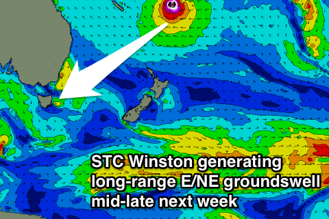
East/northeasterly energy will likely be the dominant source of swell on Saturday as the last hints of southerly energy fade. The long range trade energy generated by the interaction between STC Winston and a strong ridge to the south is expected to provide subtle ebbs and pulses in the 1-2ft range, easing during Sunday, although remaining inconsistent.
Wednesday morning’s satellite pass has observed southeasterly fetches off the back of this week’s cut-off low over southeastern parts of the Tasman of around 30-35kts, although for only a brief amount of time. This fetch soon swung more southerly and the alignment worsened as time went on.
South facing beaches should still pick up around 2ft off this brief period of favourable alignment on Saturday, with smaller sideband energy filling in thereafter.
A final source of swell should also fill in across south swell magnets on Saturday generated by a frontal progression moving south of Tasmania during today. This system is steering a fairly strong but poorly aligned west/southwesterly fetch through the southern swell window. The alignment of this fetch is way less than ideal, but the 40-45kt core winds still have the potential to provide sideband energy breaking across the exposed south swell magnets in the 1-2ft range.
Breezes look to be light/variable-offshore early on Saturday morning, increase from the north/northeast in the afternoon. Similarly, light winds are on the cards for Sunday morning, although a north/northeasterly breeze looks to come in from mid-morning.
Next week (Monday 22nd onward):
Most swell sources should fade into Monday, with left over background energy providing small options across most beaches.
A weak northeasterly fetch extending northward to the South Coast of NSW looks to develop on Sunday, adding a small amount of windswell into the mix for Monday, with modest peaks in the 1ft+ range across open beaches.
A northwesterly breeze should keep conditions clean during the morning, with a northeasterly seabreeze picking up in the afternoon.
Following a brief reprieve, a north/northeasterly fetch should redevelop, although this time stronger and spanning further north along the NSW coast on Tuesday. The southern extent of this fetch looks to have poor alignment to the Tasmanian coast, however open beaches again look to build to around 2ft by Wednesday morning, fading rapidly thereafter.
A more dominant swell source looks to fill in later on Tuesday from the long range northeasterly swell window.
STC Winston has been slowly drifting westward over the past few days and looks to continue on it’s path until Monday (hopefully not bringing too much impact to the Pacific Islands).
From that point, this system then looks to move south, dropping further into the NSW swell window steering an increasingly favourable easterly flow along the southern quadrants as it interacts with a Tasman Ridge.
 The Tasman ridge itself has been maintaining an elongated east/southeasterly airflow over the past few days which should provide an increase in trade energy later on Tuesday.
Inconsistent sets look to break across open beaches in the 2ft+ range on Tuesday.
Again, the early morning holds the best chance for a clean wave under a light northwesterly breezes. Options then look to be limited to protected northern corners as a northerly breeze increases from mid-late morning.
East/northeasterly energy looks to be prolonged, potentially sustaining for a week and growing slowly as the fetches become more favourably aligned.
Open beaches look to ebb and pulse in the days following, particularly from Thursday onwards, before building further as this system drops southward rapidly.
The southward motion of Winston is likely to be the his last tour of the Tasman, moving south towards New Zealand relatively quickly. Nevertheless, the system looks to maintain intensity as it likely undergoes extra-tropical transition.
Energy from this stage of it's life cycle looks to fill in across open beaches on the weekend, with strong sets a good chance.