Large stormy weekend, fading into next week

Eastern Tasmania Surf Forecast by Guy Dixon (issued Friday 29th January)
Best Days: Possibly Monday afternoon at protected southern corners, Tuesday morning and Wednesday morning.
Recap: Building stormy waves with no real decent options, continuing today.
This weekend (Saturday 30th - Sunday 31st):
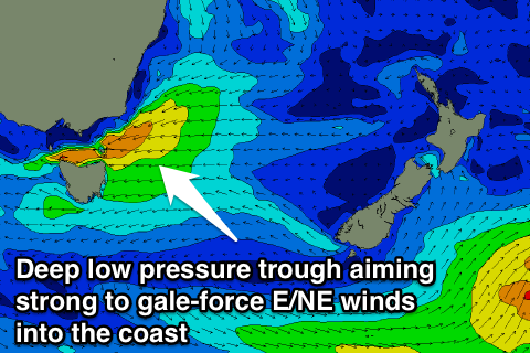 A local east/northeasterly fetch looks to increase and linger off our doorstep this weekend as the pressure gradient tightens between a deep low pressure trough and a strong Tasman ridge.
East/northeasterly fetches of 25-30kts are forecast to push into northeastern parts of Tasmania, providing a poor quality building windswell over the weekend.
Alignment to the coasts around Bicheno, Scamander and St Helens should improve throughout today, allowing the surf to build to the 4-6ft range by the afternoon.
Intensifications overnight should provide yet more size for Saturday morning, with stormy conditions reaching their peak in the 6ft+ range.
This system should continue to generate plenty of swell for Sunday, although easing slightly, maintaining surf in the 5-6ft+ range, before breaking down and being excluded to the east late in the day.
Fresh/strong east/northeasterly breezes will make damn near impossible to find a decent wave each day, not to mention the colossal amounts of rain forecast which have the potential to cause flooding and some pretty dicey water quality.
I can’t imagine there would be much motivation for a paddle, unfortunately.
Next week (Monday 1st onward):
This large, poor quality windswell should fade steadily throughout Monday from the 3-5ft range.
Although winds have the potential to drop and become light/variable overnight and into the early morning (some models disagree and indicate early arrival of a southerly flow), I would expect to see plenty of residual bump and scarring in the mix for the morning session.
A southerly airflow then looks to become established throughout the day, leading to poor quality options at south facing beaches. Protected corners of the open beaches may have a workable wave of variable quality in the afternoon.
All swell sources should continue to fade in the following days as each swell window takes a break.
Tuesday should start off under a light/variable southerly airflow, becoming light northeasterly in the afternoon. Wednesday morning looks to offer a northwesterly breeze early cleaning things up, with the potential for a seabreeze later.
There are indications of a small east/northeasterly swell building late in the week of a northeasterly fetch just west of New Zealand, although this fetch lacks ideal alignment and intensity, so it’s not really worth hanging much hope on.
More detail to come next week.