Multiple E/NE swells in the water. Thursday morning looking good

Eastern Tasmania Surf Forecast by Guy Dixon (issued Wednesday 6th January)
Best Days: Thursday morning.
Recap:
The very early risers may have scored a clean 2-3ft wave on Tuesday morning, but the northeasterly seabreeze soon came in and made for bumpy conditions. It was a similar story this morning, with nice 2-3ft options across the open beaches, preceding a light southerly wind change.
This week (Thursday 7th - Friday 8th):
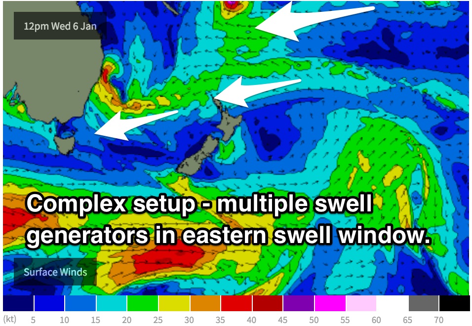
A Tasman ridge has been steering a broad east/northeasterly fetch just to the north and east of New Zealand’s North Island over the past couple of days and should continue delivering 2-3ft surf to the opten beaches on Thursday.
Light variable winds are on the cards for the early session, before increasing from the southeast and eventually east throughout the day.
However, this broad easterly fetch is currently being dissected by a deepening low pressure system off the coast of NSW.
As this low continues to deepen this evening, an intensification along the southern quadrants of the low will steer a gusty east/northeasterly fetch with winds of 30-35kts towards northern Tasmania, followed by a broader, weaker fetch of northeasterly winds.
 Without forgetting the existing east/northeasterly trade energy, the resultant swell off these systems should provide peaks in the 3ft range across the open beaches on Friday.
A long range east/northeasterly swell generated by Tropical Cyclone Ula will also be in the mix, providing inconsistent sets in the 3ft range across the open beaches.
A strong frontal progression is due to move to the south of Tasmania on Thursday evening, with broad west/southwesterly fetches of 35-45kts. Despite the less than alignment, long period sideband energy has the potential to provide 2-3ft sets across the more exposed southerly swell magnets on Friday, peaking in the late afternoon.
By the time the swell is at its largest, a gusty northerly airflow should have become established. These south facing beaches should then be offering the cleanest options.
Otherwise, open beaches will best in the morning, becoming wind affected by the afternoon.
This weekend (Saturday 9th - Sunday 10th):
The mixture of southerly groundswell and east/northeasterly swell should fade throughout the day, with early Saturday morning still seeing the odd 2-3ft set at the exposed swell magnets.
Winds look to be light/variable-offshore for most of the morning, becoming seabreezey from early afternoon.
On Sunday, a second, much smaller pulse of southerly groundswell should fill in across the exposed south swell magnets from a poorly aligned, weak front in the days prior. The impacts of this swell are only likely to be modest, maybe just over 1ft at the magnets under light winds which are due to increase from the northeast in the afternoon.
Next week (Monday 11th onward):
The early stages of next week look to start off slow, with long range east/northeasterly energy from Tropical Cyclone Ula continuing to provide small, inconsistent options in the 2ft range across the open beaches.
However, an increasing northerly flow looks to develop off the coast of NSW and over eastern parts of Bass Strait from late on Sunday, allowing for a northeasterly windswell to build on Monday.
Open beaches should see small and weak 1-2ft peaks, impacted by the same north/northeasterly breezes which are generating them.
As quickly as this system developed, it’ll shift its alignment offshore and the swell will dwindle. Tuesday may see hints of north/northeasterly swell as a small fetch sits off the South Coast of NSW late on Monday, but only modest.