Easing NE swell, short range S'ly swell for the weekend

Eastern Tasmania Surf Forecast by Guy Dixon (issued Friday 13th November)
Best Days: Saturday morning and Sunday morning
Recap:
The surf increased steadily across open beaches on Thursday as a solid northeasterly swell filled in. Unfortunately, conditions were hampered by a gusty northeasterly breeze, tending easterly at times, making it very difficult to find anything worth while.
By this morning, the northeasterly swell was breaking more or less on target, with some reports of 6ft sets at St Helens. The surf was on the pump under a calm/light southerly breeze. From late morning, these southerly breeze increased, limiting options to proctected southern corners of open beaches, before adopting a more easterly airflow and easing by late afternoon. These southerly breezes have also whippied up a short range southerly swell to around 2-3ft at exposed south facing beaches.
This weekend (Saturday 14th - Sunday 15th):
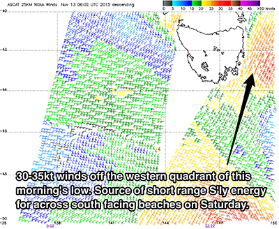
Today’s northeasterly swell will fade into Saturday morning, however open beaches will still have a good amount of energy with options in the 2-3ft range. There is also likely to be a fair amount of short range southerly energy in the water whipped up today by gale force breezes on the western quadrants of a low pressure system.
 South facing beaches can expect peaks of variable quality in the 2-3ft range, possibly larger at the exposed magnets. Light westerly breezes are forecast for the Saturday morning, tending light variable by mind morning before eventually swinging south/southeasterly and increasing in the afternoon. There should be plenty of options for a surf across the coast, potentially a bit raw early in the morning at south facing beaches.
The south/southeasterly breezes which are due to increase on Saturday afternoon will provide a small amount of low quality swell for south facing beaches on Sunday morning, although steadily fading from the 1-2ft range. Similarly, open beaches are expected to see the last of the northeasterly swell, easing from the 1-2ft mark throughout the day.
Breezes are set to be light southerly in the morning, becoming variable by mid-morning before adopting a moderate northeasterly flow in the afternoon.
Next week (Monday 16th - Friday 20th):
Monday is looking like a lay day in terms of surf, there are very few indications of fresh swell worth speaking of, with the exception of a small increase in northeasterly windswell as northerly breeze increase in the afternoon. Nothing overly impressive, just low quality peaks in the 1-2ft range at open beaches.
Throughout Tuesday, the more exposed south swell magnets have the potential to pick up a southerly groundswell generated by a poorly aligned front moving south of Tasmania late on Sunday, with inconsistent peaks in the 2ft range. The source of this swell is hardly within the swell window, however the long period nature may allow for some refracted energy to break across the most exposed magnets.
This inconsistent groundswell, will continue to be the more dominant swell for Wednesday, however likely undersized in the 1-2ft range at south facing beaches.
The remainder of the week looks to remain fairly quiet, with subtle ebbs and pulses holding the surf in the 1-2ft range, most active at south facing beaches of weak frontal activity.