Sizey NE swell to end the week

Eastern Tasmania Surf Forecast by Guy Dixon (issued Wednesday 11th November)
Best Days: Friday morning at open beaches.
Recap:
Following a southerly change, exposed south facing beaches built to the 2-3ft range on Tuesday, however these gusty southerly breezes had an impact on the quality, limiting options to protected southern corners where it was much smaller.
A southelry groundswell generated by more substantial fetches is breaking across south facing beaches today however a light/moderate southerly breezes has continued to blow. Breezes have recently swung easterly at St Helens, so conditions are pretty unappealing.
This week (Thursday 12th - Friday 13th):
Over the past few days we have been keeping our eye on a deepening trough over mainland Australia which is set to interact with a strong Tasman ridge. The pressure gradient between these two synoptic features is set to tighten allowing a northeasterly fetch to increase over western parts of the Tasman Sea.
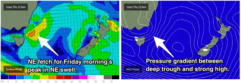 This healthy northeasterly fetch which is set to generate 30-35kt core winds is likely to whip up a solid northeasterly swell for open beaches on Thursday, building to the 3-5ft range by the afternoon.
Unfortunately, local breezes are also likely to prevail from the east/northeast throughout the morning and afternoon, however this airflow looks to be much lighter down around Scamander in the morning. The quality of the surf isn’t going to be amazing, even if you try to make the most of a small southerly groundswell which is likely to be producing 2ft peaks at south swell magnets.
However, Friday brings more promising prospects. Models have come into better alignment regarding the development and location of a low pressure system. This low is likely to develop off the coast of northeastern Tasmania in the vary late hours of Thursday, into the early hours of Friday morning. As a result, south/southwesterly winds are likely to be dominating over along the coast of eastern Tasmania by daybreak on Friday.
Protected southern corners of open beaches are the spots to keep in mind for Friday, as they will be handling southerly breezes while picking up plenty of east/northeasterly swell. The surf should have peaked in the early hours of Friday morning, easing from the 3-5ft range throughout the day.
These southerly breezes will also whip up a short range windswell peaking in the 3-4ft range at south facing beaches in the afternoon, however the quality of the surf at these exposed locations is not looking good.
Brisk southerly breezes will add a lot of lump and bump into the mix, making it difficult to find any decent set ups. Some models suggest that the low will move east late in the day allowing winds to ease, however residual scarring is still likely to limit options.
This weekend (Saturday 14th - Sunday 15th):
By Saturday morning, we will be left with fading remnants of short range southerly energy at south facing beaches and east/northeasterly energy at open beaches.
Both swell sources by this stage will be coming to the end of their life cycle. Open beaches will fade from the 2-3ft range throughout the day, while south facing beaches will fade from the 2ft range.
On the plus side, winds will be light/variable offshore right along the coast in the morning, swinging light onshore by late morning/early afternoon. There should be workable options for weekend warriors at a good variety of spots to start the weekend.
Sunday should see all coast continue to fade back to the 1-2ft range under light variable winds in the morning. A northerly breeze is expected to increase in the afternoon, however the lack of swell makes this information semi-redundant.
Next week (Monday 16th onward):
Sunday’s conditions really set the tone for the early stages of next week. There are very few indications of significant swell on the horizon. We will be forced to rely on weak frontal activity for subtle ebbs and pulses of inconsistent swell in the 1-2ft range.