Strong SE groundswell tomorrow, S'ly swell next week

Eastern Tasmania Forecast by Craig Brokensha (issued Wednesday 3rd June)
Best Days: Thursday morning, Friday, Saturday morning, later Tuesday, Wednesday, Thursday
Recap
Fun levels of S'ly swell the last couple of days around the 2-3ft range across south swell magnets, while this afternoon signs of a stronger new SE groundswell should have been seen across the coast.
 This week and weekend (Jun 4 - 7)
The strong and broad Tasman Low sitting over near New Zealand has produced a good SE groundswell pulse for tomorrow, with satellite observations showing a fetch of S/SE gales on the edge of our swell window.
This should come in at a strong 3-5ft across the coast tomorrow morning, easing into the afternoon and further from 3ft+ Friday morning and then down from 2ft+ Saturday morning.
This easing trend is slowed by a persistent fetch of weakening SE winds off the tip of New Zealand's South Island.
Conditions will be great with W/NW tending N/NE winds tomorrow, W/NW tending variable winds Friday and all day offshores Saturday. Sunday will remain clean but be tiny.
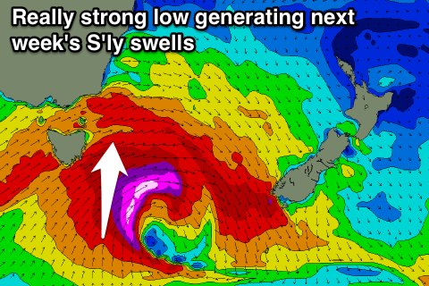
Next week onwards (Jun 8 onwards)
Our next increase in swell will be an acute but good S'ly groundswell Tuesday afternoon and Wednesday, generated by a strengthening frontal system pushing across the state on Monday night.
This front will generate a fetch of severe-gale to storm-force W/SW winds through our southern swell window, followed by a better aligned fetch of S/SW gales on its tale.
An initial acute S'ly groundswell pulse is due Tuesday afternoon to 3-4ft across south facing beaches late in the day under W'ly winds, while a larger S'ly groundswell pulse is due Wednesday from the backside of the low to 4-5ft. Winds look to be favourable for this as well, with the swell easing from the S/SE under offshores Thursday. More on this Friday though.