Plenty of swell all week, best from Wednesday

Eastern Tasmania Forecast by Craig Brokensha (issued Monday 1st June)
Best Days: Wednesday morning through Saturday
Recap
Small easing 1-2ft waves Saturday, becoming flat into yesterday and further today. A new S'ly swell should have built through today though although winds are less than ideal.
 This week and weekend (Jun 1 - 7)
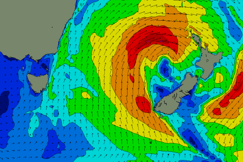
A relatively weak front pushing up past us last night and today, has strengthened off our coast this afternoon and will be followed by a secondary system pushing up through tomorrow.
With this a weak and persistent fetch of S'ly winds off our coast should generate some good S'ly for tomorrow and Wednesday coming in at 3ft across south facing beaches.
At polar latitudes a fetch of S/SW gales in our swell window this evening should generate a stronger S'ly groundswell pulse for Thursday morning and this should keep 3ft sets hitting south facing beaches.
Also in the mix at the same time will be a good SE swell, generated by a broad and slow moving low pressure system across New Zealand. At the base of this low, a fetch of strong to gale-force SE winds will be aimed mainly towards NSW and SE Queensland, with some SE swell spreading off radially into us from Thursday through until Saturday. Size wise we're looking at 3-4ft surf from Wednesday afternoon through Thursday, backing off to 3ft+ Friday and down from 2ft+ Saturday morning.
Winds in general should improve from tomorrow with less favourable SW-S/SW breezes, W/SW tending S'ly winds Wednesday and then good offshore W/NW winds from Thursday into the weekend.
Longer term there's nothing significant at all on the cards, so make the most of the coming swell!