Fun pulses of southerly swell

Eastern Tasmania Forecast by Craig Brokensha (issued Monday 18th May)
Best Days: Early Tuesday south swell magnets, Friday south swell magnets, Saturday south swell magnets, Sunday south swell magnets, Tuesday south swell magnets
Recap
Great waves Saturday with an easing SE swell from 3-4ft across exposed spots with favourable winds, while the swell was all but gone Sunday with 1ft to occasionally 2ft waves across swell magnets. Today the coast was tiny but clean.
 This week (May 19 - 22)
We've got planty of S'ly swell on the way this week as a series of strong polar fronts push through our southern swell window, along the polar shelf.
This first is due tomorrow, generated over the weekend but we should see infrequent 2ft+ across south swell magnets under fresh N/NW winds early, with the swell easing through the day.
Wednesday will be tiny, with a weak increase in S/SE windswell through the afternoon as a surface trough moves in from the west, directing a strengthening fetch of S/SE winds up our coast.
This isn't expected to generate any major size, with small 2ft wave late in the day, easing through Thursday.
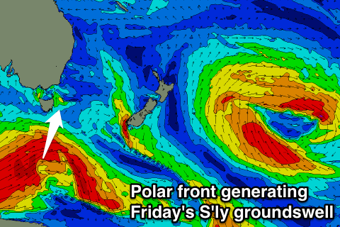
The best pulse of S'ly groundswell is due Friday, generated by a vigorous polar low forming south-west of the state overnight Tuesday, projecting a fetch of severe-gale W/SW winds through our swell window.
This should produce an inconsistent but good S'ly groundswell, peaking Friday morning to 2ft+ at open beaches and 3-4ft+ at south swell magnets.
Winds should be favourable and light offshore from the West before swinging SE into the afternoon.
Into the weekend the swell should drop away from 2ft across south swell magnets, but a new pulse is due through the afternoon, back to 3ft+. Winds will be favourable and offshore from the W/NW tending SW, with a drop in size due into Sunday morning.
Another pulse of S'ly groundswell is due Sunday afternoon, from a small but strong polar front pushing through our swell window later in the week, but a kick to 2ft+ or so is expected across south swell magnets.
On the backside of this low, a better aimed fetch of S/SW gales are due to be aimed through our swell window Saturday evening and Sunday morning, producing a new S/SE groundswell for Tuesday to 2-3ft across south facing beaches and with favourable W/NW winds. More on this Wednesday though.