Fun swell from the east from Thursday

Eastern Tasmania Forecast by Craig Brokensha (issued Monday 20th April)
Best Days: Every day from Wednesday afternoon
Recap
Tiny waves Saturday and Sunday morning ahead of a late kick in S'ly windswell along with a S'ly change. Today the swell was easing from 1-2ft across open beaches, and with a touch more size likely at south swell magnets under offshore winds.
 This week and weekend (Apr 21 - 26)
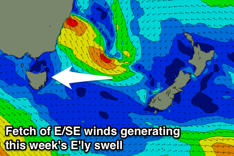
Tomorrow should be tiny with the S'ly swell continuing to fade away and then all our attention will swing to a deepening East Coast Low off the Southern NSW coast.
This low is currently just a touch too far north and out of our swell window, but we should see it broadening in scope through tomorrow, with a fetch of strong to gale-force E/SE winds on its southern flank being aimed more towards us.
This fetch is even forecast to retro-grade slightly back to the west and towards us Wednesday, helping to produce a good pulse of E'ly groundswell for Wednesday and Thursday.
We should see open beaches building to 2-3ft Wednesday afternoon and then 3-4ft+ Thursday.
We may see the swell continuing to hold a similar size range into Friday morning before easing during the day as the low starts to dissipate.
Some new E/NE swell should replace the easing E'ly swell though, generated from an in-feed of strong E/NE winds on the eastern flank of the ECL, encroaching closer to us Wednesday and Thursday.
A late kick in size may be seen Friday to 3-4ft before peaking Saturday to 3-4ft and then slowly easing through the afternoon and from 2-3ft Sunday morning.
Winds look favourable for most of this period with morning offshores, but we'll review this again Wednesday.
Into next week we may see some new S'ly swell developing across the coast, but we'll have a closer look at this as well on Wednesday.