Small average mix of swells until next week

Eastern Tasmania Forecast by Craig Brokensha (issued Wednesday 10th December)
Best Days: Southern corners tomorrow for keen surfers, Sunday morning northern corners for keen surfers, Wednesday morning, Thursday
Recap
A mix of E/NE and smaller SE swell continued to 3ft+ across the coast yesterday morning as winds from the southern quadrant favoured protected southern corners. Today the NE swell was smaller again and with light to moderate NE winds, limiting surfing options.
This week through next week (Dec 11 - 19)
A small kick in NE windswell is due to keep 1-2ft sets hitting open beaches through tomorrow and the early morning will be best with an offshore breeze before a gusty S/SE change moves through. With this a small S/SE windswell is due but not above 1-2ft Friday morning. Conditions should be clean though with an early SW breeze. A small SE swell to a similar size Saturday morning may be seen from a small fetch of SE winds off the tip of NZ's South Island but not above 2ft on the sets.
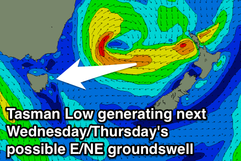 Of greater interest, the Tasman Low forming off the Southern NSW Coast is initially due to be out of our swell window and off the Sydney/Newcastle region through Thursday, Friday and Saturday. This will result in us receiving no swell until the system starts drifting south and into our swell window around Saturday evening.
Now the models are still divergent on the lows track but we'll most likely see it drifting south-southeast towards New Zealand aiming a fetch of strong to gale-force E/NE winds towards us as it does so.
This should generate a strong pulse of E/NE groundswell for Wednesday and Thursday that at this stage looks to come in either side of 4-5ft at its peak. There's still a lot of movement around the track and intensity of this low though, so we'll review this system again on Friday.
Before this swell arrives though a fetch of NE winds developing off our coast through Saturday evening should produce a peaky but onshore 2-3ft of NE windswell for Sunday. The fetch is due to persist through Monday but weaken resulting in the swell persisting but dropping back to 2ft or so as winds hold from the N/NE (possibly N/NW early each morning).
Winds should finally swing around to the S'th Wednesday as a trough moves across us, and this will bode well for offshore winds developing for Thursday's E/NE groundswell pulse. More on this Friday though.