Friday the pick of the week

Eastern Tasmania Forecast by Craig Brokensha (issued Monday 4th of August)
Best Days: Tuesday afternoon, early Wednesday, Thursday afternoon, Friday
Recap
A fresh pulse of S/SE swell was seen Saturday to 2-3ft across open beaches with bigger waves at south swell magnets under favourable W/SW winds. This swell eased back to a smaller 1-2ft Sunday but winds were better for exposed locations and from the NW. Today the surf is tiny but we've got a few pulses of swell on the cards for the coming week.
This week (Aug 4 - 8)
Tomorrow morning is expected to start out flat but a vigorous and fast moving polar front pushing through our swell window overnight should generate a fetch of severe-gale to storm-force W/SW winds. This should produce a fresh spike of S'ly groundswell across south swell magnets tomorrow afternoon to 2-3ft. Remaining open beaches are likely to be tiny but W/NW winds will favour exposed breaks.
This swell will drop rapidly through Wednesday due to the quick movement of the front, but south swell magnets may still offer the odd 2ft to occasional 3ft set early.
The next pulse of S'ly groundswell is due through Thursday but this will be more short-range energy as a strong cold front pushes up past our coast. A fetch of strong SW winds should produce 2-3ft waves at south swell magnets through the day but with improving SW tending variable winds.
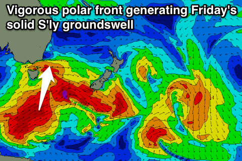 Friday is the pick of the week though as a strong S'ly groundswell fills in. This will be generated in the wake of Thursday's front, with a fetch of severe-gale SW winds being projected from below the state up towards New Zealand but through our southern swell window.
This should see open beaches coming in at 2ft to occasionally 3ft, while south facing breaks should see 4ft+ sets. Winds look great as well with a fresh NW breeze.
This weekend onwards (Aug 9 onwards)
Friday's swell will drop away considerably overnight Friday leaving small 1-2ft leftovers across south swell magnets. We may see some new S'ly swell energy into Sunday afternoon and Monday as another vigorous polar front pushes up past us, but we'll review this Wednesday.