Average outlook, best Saturday

Eastern Tasmania Forecast by Craig Brokensha (issued Monday 14th July)
Best Days: Wednesday morning for desperate surfers, Saturday
Recap
The weekend was great with a gradual drop in E'ly groundswell from late last week under offshore winds. A change through yesterday brought with it a fresh pulse of S/SE swell today, keeping fun 2-3ft waves hitting the coast this morning. This swell should of eased into this afternoon as conditions become bumpy with an onshore NE wind.
This week and weekend (Jul 15 - 20)
Tomorrow isn't looking too flash with a tiny mix of swells due under N/NW winds. A strengthening northerly ridge that was forecast to kick up some new N/NE windswell is expected to be a little weaker now and only a late increase in size is due tomorrow with a further increase due overnight.
Size wise we're only looking at 2ft+ waves Wednesday morning at north-east facing breaks ahead of a drop into the afternoon as winds swing fresh NW. This will provide weak peaky waves if you're desperate for a surf.
The end of the week is looking a little more interesting, but also tricky.
A vigorous cold front pushing across us and into the Tasman Sea on Friday is due to project a fetch of gale to severe-gale SW tending S/SW winds up past our coast during the day, but there may be too much west in the wind to see any real size across our region.
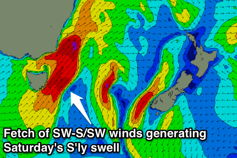 We're likely to see a late spike to 3ft or so across south facing beaches late Friday with S/SW winds ahead of a peak overnight and then quick drop from 3-4ft Saturday morning.
Saturday morning looks like the time to surf as winds swing straighter W'ly, creating favourable conditions at more exposed spots.
After Saturday's swell eases, there's nothing too major on the cards, but check back here on Wednesday for any change to the outlook.