Fun S/SE swell Saturday, with a good mix of swells Monday and Tuesday

Eastern Tasmania Forecast by Craig Brokensha (issued Friday 20th June)
Best Days: Saturday, Monday in protected northern corners, Tuesday
Recap
A small S'ly swell was visible across south swell magnets yesterday, but not to much size. This swell has eased back overnight with tiny waves left into this morning.
This weekend and Monday (Jun 21 - 23)
Tomorrow's pulse of S/SE groundswell is still on track, with open beaches expected to build to an inconsistent 2ft to occasionally 3ft during the day. Early morning will probably be a touch smaller. Light W/NW tending N/NW winds should create favourable conditions most of the day.
The swell should dip away into Sunday but a new increase in longer-range SE swell is due into the afternoon ahead of a peak Monday to 2-3ft across open beaches with the possibility of the odd bigger set.
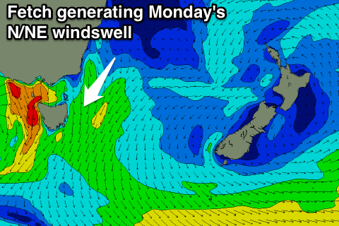 Unfortunately strong N/NW winds will limit surfing options to northern corners, but also kick up a peaky N/NE windswell to 2-3ft or so during the afternoon.
Come Tuesday both the N/NE windswell and SE swell should back away from a peaky but fun 2ft across open beaches under freshening offshores.
Longer term there's nothing too major on the cards as a series of vigorous but zonal cold fronts push across us. No considerable size is due at this stage, but we'll review this Wednesday.