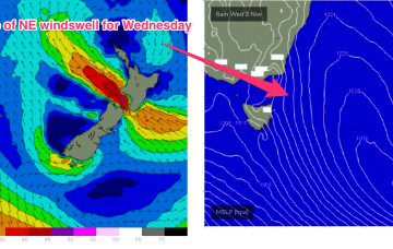
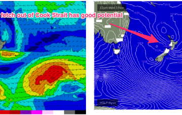
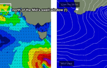
Average weekend, then a nice round of swell for the east
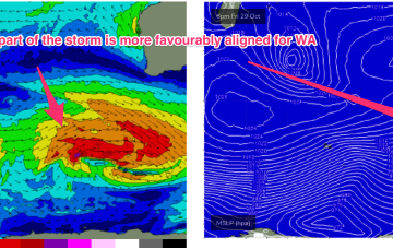
It’s gonna take quite a bit of effort to clean up conditions from today’s blow.
No change to the headline feature: another robust low forming in a trough line East of Tasmania. It does seem to be running early, with gales to storm force winds now occurring out of Bass Strait through the early afternoon and severe gales expected to form adjacent to the East Coast overnight.
In addition to S swell there’s quite a strong high pressure surge of SE winds developing over the weekend. This surge of 20-30knot SE winds is likely to push wave heights up into the 3ft+ range, especially in SEQLD, through Sun.
No change to the headline feature this weekend: another robust low forming in a trough line East of Tasmania. It does seem to be running early, with gales to storm force winds now expected out of Bass Strait through the early afternoon and winds now tending SW through the evening in Southern NSW.
First things first - there’s no new groundswell on the way for the next few days. But we have waves for next week!
Swell production has been suppressed by an unfavourable node of the long wave trough and that is expected to partially break down over the weekend with a moderate strength storm located in the region between 80-100E between 40-50S.
With no new groundswell expected for the next few days, it’ll be slim pickings across all coasts. But next week has some good surf ahead.
Friday will see developing SE tending S/SW gales, as the low crosses through Bass Strait.
The weekend looks more reliable as the low moves away during Sat, with gales to severe gales on the western flank of the low generating another strong pulse of S swell for Sat. Expect surf in the 3-5ft range during Sat, with fresh W’ly quarter winds during the day.
Eventually the low pressure system tracks into the Tasman, and with an associated front forms a low in the active window E of Tasmania overnight Fri/early Saturday. That will see some new S swell arriving on the weekend.