Building long-period SW groundswells

Bali and Mentawais forecast by Craig Brokensha (issued Tuesday 25th September)
Best Days: Thursday onwards
This week through next weekend (Sep 26 – Oct 5)
Bali: The swell bottomed out over the weekend, but today we should be seeing a new mid-period S/SW swell building across magnets and reaching the 4ft range this afternoon (much smaller on the Bukit).
Expect the swell to drop from a similar size tomorrow morning ahead of the first of our long-period SW groundswells due through the coming period.
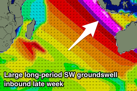 Thursday's first long-period SW groundswell will be the most consistent, generated over the weekend by a very intense mid-latitude low forming north of the Heard Island region, tracking east towards Western Australia.
Core wind speeds reached the storm-force range and with this, a strong long-period SW groundswell is expected.
A slight upgrade in size is also due, with the swell arriving Wednesday afternoon, building late and peaking Thursday morning to a strong 6ft on the sets, if not for the odd sneaker.
A drop in size should be seen through Friday morning ahead of our very inconsistent long-range SW groundswell arriving into the afternoon and building towards a peak through Saturday afternoon and evening.
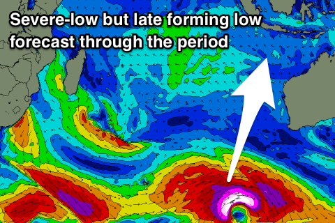
This groundswell started to be generated Thursday last week as a very strong storm formed south-east of South Africa, projecting a slow moving fetch of severe-gale to sometimes storm-force W/SW winds through our distant swell window.
The storm pushed further east towards the Heard Island region before breaking down yesterday, with the long-period and very inconsistent SW groundswell now heading through the Indian Ocean towards us.
The forerunners are due to arrive Friday with an afternoon increase in size to 4-5ft+, building further Saturday and reaching 6-8ft at swell magnets through the afternoon, peaking overnight and easing from a similar size Sunday.
 Looking at the expected winds over the coming period and we've got a relaxation of the trades and with this each morning should see variable breeze, with more S'ly winds into the afternoons, reverting back to the S/SE-SE from Friday through Sunday.
From Monday next week though we should see E/SE trades proper kick back in, possibly swinging more SE later week but more on this Thursday.
Our next increase in swell will be out of the S/SW, with multiple pulses from this direction as a series of vigorous polar fronts develop south-west of WA, with the first possibly being the most significant.
We're expected to see a very significant polar low forming between Heard Island and Western Australia, generating a large long-period S/SW groundswell for late next week/weekend, but more on this Thursday.
16 day Bali Forecast Graph
16 day East Java Forecast Graph
16 day Sumbawa Forecast Graph
Ments: The surf should be bottoming out across the region today, but our initial pulse of long-period S/SW groundswell is due to fill in tomorrow, kicking to a strong 5-6ft, easing back through Thursday.
The larger and more powerful long-period SW groundswell is due to kick very strongly through Friday, reaching 8ft on the sets by dark across magnets, with a peak Saturday to a similar size, if not for the odd bigger cleanup.
From here we're looking at a steady easing trend through Sunday and early next week, smaller through the end of the week and weekend.
This will be a result of the S/SW groundswell energy for Bali being generated too far east and mostly out of our swell window.
Our persistent and fresh SE-S/SE winds are due through the entire period, favouring more protected breaks, and becoming strong through the weekend before easing off next week.
16 day Mentawai forecast graph
16 day Nias forecast graph
16 day South Sumatra forecast graph