Overactive forecast period for Indonesia

Bali and Mentawais forecast by Craig Brokensha (issued Thursday 12th July)
Best Days: Saturday onwards for experienced surfers, protected spots out of the SE trades in the Ments from tomorrow afternoon
This week and next (Jul 14 - 20)
Bali: Some new S/SW groundswell should have been seen through yesterday, and this morning, with an easing trend due through today.
There's been no change to the mid-period SW swell due later tomorrow and Saturday with sets to 4-5ft+ likely across swell magnets ahead of our much larger and more powerful long-period SW groundswell Sunday.
Also there's been no real change to the expected size from this well aligned groundswell, with a strong mid-latitude front that formed south-east of South Africa earlier this week moving slowly east while aiming winds from gale-force to just on storm-force through our swell window.
We should see this swell fill in on Sunday and peak through the afternoon to a large and powerful 10ft on the sets across magnets, with 6-8ft sets due for the Padang Cup if they run. Winds should be variable early before moderate to fresh SE trades kick in.
A slow drop in size is expected on Monday from 8ft+ or so at magnets, smaller into Tuesday morning.
 We then look towards the back to back pulses of large to extra-large S/SW groundswell due through the middle to end of next week.
A strong node of the Long Wave Trough is currently developing west of WA and with this we're seeing a flurry of back to back frontal systems pushing through our southern swell window.
An initial polar low that formed west of Heard Island has been generating a fetch of gale to severe-gale W'ly winds through our far swell window, producing an inconsistent long-period S/SW groundswell for later Tuesday, peaking Wednesday morning.
This swell looks to come in at 6-8ft across swell magnets along with moderate to fresh E/SE trades (lighter and more variable early morning).
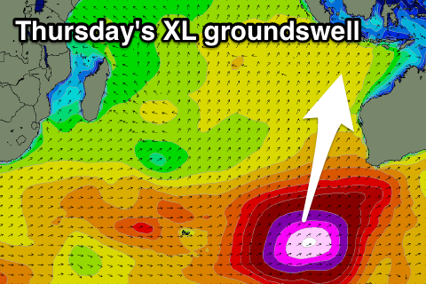
Of greater significance is a broad fetch of severe-gale W/NW winds swinging in on the back of the active sea state generated by this initial storm, swinging more W/SW while projecting up towards southern Australia.
This will produce an oversized long-period S/SW groundswell by itself, but an additional storm-force fetch of W/SW winds on the tail of this progression, projected up through our southern swell window will produce an XL S/SW groundswell.
It looks like we'll see both swells arrive around the same time, that being late in the day Wednesday and peaking Thursday. The models are over-forecasting the size and incorrectly combining the seperate swells, but still we're looking at large dangerous 12ft+ sets across exposed breaks through Thursday, easing back into Friday from the 10ft range.
Beyond this a secondary strong amplification of the Long Wave Trough is set to produce further large to extra-large surf into the week starting the 23rd of July, but we'll have a closer look at this Tuesday.
16 day Bali Forecast Graph
16 day East Java Forecast Graph
16 day Sumbawa Forecast Graph
Ments: A bit more energy across the islands the last couple of days but from tomorrow we'll see those fresh SE winds really start to kick in along with the new pulses of swell.
Firstly tomorrow some new mid-period SW swell should build to 4-5ft+ through the afternoon across magnets, easing back slightly through Saturday morning.
The large and powerful long-period SW groundswell will arrive into the afternoon and likely kick strongly to at least 6-8ft by dark at magnets, with a peak to 10ft due Sunday morning. Those SE winds will really limit the best waves to more protected breaks though, with the swell easing into the afternoon, further Monday.
Looking at the longer term wind outlook, the models diverge a little from Thursday next week with easing and better E/SE trades on the cards when looking at the American solution, but the European model still has SE winds persisting. So we'll have to go over this again on Tuesday.
The inconsistent long-period S/SW groundswell from the polar low is due to fill in Tuesday, boosting magnets to 6ft+ into the afternoon, easing back from a similar size Wednesday morning.
Now, the activity firing up south-west of WA won't be too favourably aligned for us, but with the width and scope of the storms, we'll still see very large and powerful groundswell energy arriving out of the S'th on Thursday, kicking strongly to 10ft+, if not bigger at magnets into the afternoon.
The extra south in the swell will see less size refracting into protected spots, but the extra long-periods should overcome this somewhat.
The longer term outlook is similar to Bali with large to extra-large long-period groundswells due through the week starting to 23rd, but more on this next update.
16 day Mentawai forecast graph
16 day Nias forecast graph
16 day South Sumatra forecast graph
Comments
Thursday looks a bit challenging with tides and size at Ulu. Big deep high coinciding with swell peak. Friday morning Outside Corner could be epic if it pushes back slightly. Reckon the models run hot for early Fri?
Craig do you think Padang comp will run tomorrow Not a lot of swell on the Bukit at moment..overnight rise maybe ?
fck me has anyone seen the upgrade for the swell peaking on Wednesday 25th July? Its upgraded substantially, now reading 5.3m at 17secs SSW. I'm shitting myself. Hoping its one of those swells that lights up rare inside perfect reefs
It's combining two swells so it's over cooking it somewhat.
Hey Don
Not wanting to overtake this thread, but.....What are your thoughts for swell in the Maldives in the long term from next Saturday 21st onwards, considering the extremely active Indian Ocean forecasts.
Cheers
Potential 2pm start for Padang comp today.