Strong swell for Monday, followed by good swell Thursday and following weekend

Bali and Mentawais forecast by Craig Brokensha (issued Thursday 15th September)
Best Days: Friday morning, Saturday afternon onwards
This week and next (Sep 16 - 23)
Bali: We've seen easing surf and this will continue into tomorrow, with a slight kick in inconsistent S/SW groundswell for Saturday and Sunday morning.
This swell impacted WA today and is only due to offer infrequent 4-5ft sets across south magnets into Saturday afternoon, holding Sunday to 3-5ft.
Later in the day we should see the forerunners of a large long-period S/SW groundswell arriving, peaking Monday.
This swell, generated since Sunday evening by a strong polar low firing up south-east of South Africa, has traversed the polar shelf and is now projecting towards WA in a weakened form.
 A strong pulse of S/SW groundswell is due off this system, peaking Monday to a large 6-8ft+, easing back into Tuesday from 6ft+ at magnets.
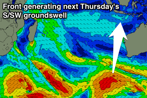
Our secondary pulse of reinforcing S/SW groundswell for Wednesday and Thursday has been upgraded a touch, with the polar frontal system generating it now expected to project towards WA instead of continuing east along the polar shelf.
This will see a larger increase in swell to 6-8ft Thursday morning, but ahead of this an initial spike is due Wednesday afternoon to 6ft.
The swell will ease back steadily Friday and into Saturday next weekend.
Longer term the outlook is good for a strong pulse of S/SW groundswell Sunday/Monday. This will be generated by a high riding frontal progression above Heard Island and towards WA the middle of next week. Early estimates are for 6-8ft of swell, but more on this Tuesday.
Moderate to fresh E/SE trades are due to develop from tomorrow afternoon across the region, persisting all off next week and into the following weekend.
16 day Bali Forecast Graph
16 day East Java Forecast Graph
16 day Sumbawa Forecast Graph
Ments: A mix of small to moderate S'ly swell is breaking across the region today and this will fade back into tomorrow.
Saturday's small pulse of S/SW groundswell which is better aimed for eastern Indonesia should kick to an inconsistent 3-5ft across exposed breaks, easing back from a similar size Sunday morning.
The larger S/SW groundswell for Monday looks good, and while not ideally in our swell window we should still see exposed south facing breaks reaching 5-6ft in the morning, easing back through the afternoon and further Tuesday and Wednesday.
The S'ly swells for Wednesday/Thursday aren't too perfectly aimed but should come in around 4-5ft+ or so, easing back slowly Friday.
Longer term the S/SW groundswell for Sunday/Monday looks good and to about 6ft+ or so but more on this Tuesday.
Winds are expected to be generally variable from the W/NW, increasing a touch into Monday.
16 day Mentawai forecast graph
16 day Nias forecast graph
16 day South Sumatra forecast graph
Comments
thinking about jumping a flight for the thursday swell, but winds look a little iffy(weak trades) for E Java- Anyone with more idea than me have any input?