Good period ahead with a large swell for Sunday week

Java, Bali, Lombok, Sumbawa forecast by Craig Brokensha (issued Thursday 21st May)
Best Days: Every day over the coming period
This week and next week (May 22 - 29)
The swell has eased back a touch into this morning with light variable winds opening up options across all locations. The trades should kick in during the day but over the coming few days we'll see them really weaken back, with the mornings seeing winds remain light and variable for longer towards midday.
A good but inconsistent and southerly S/SW groundswell is due tomorrow, generated over the weekend to the south-southwest of WA.
This swell provided good 6ft+ surf around Margaret River yesterday morning, with it due to fill in tomorrow and provide similar 5-6ft waves across exposed breaks, with the chance of the odd bigger bomb into the afternoon, when it peaks.
The swell should then drop away into the weekend, from 4-5ft+ Saturday morning and further from the 4ft range on the sets Sunday morning.
A very inconsistent long-range SW groundswell is due Monday, generated in our far swell window to the south of South Africa.
Exposed breaks are due to peak through the day Monday to an inconsistent 3-5ft, with nothing much between before easing through Tuesday.
As touched on last update, of greater importance are a couple of larger S/SW groundswell due through the middle to end of next week, generated by a couple of vigorous polar frontal systems firing up in the south-eastern Indian Ocean.
The first system is currently forming south-east of South Africa, with will generate a fetch of W/SW gales aimed towards WA.
An inconsistent but good S/SW groundswell will result, building through Wednesday and peaking into the late afternoon to 6ft+ across exposed breaks.
The swell should ease a touch into Thursday, with this easing trend slowed Friday by a secondary much weaker but favourably tracking polar front pushing up towards us during the weekend.
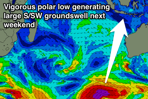
Behind this though a much stronger polar low is forecast to form south-west of WA, with a fetch of severe-gale to storm-force W/SW tending SW winds due to be aimed through our south swell window.
A large long-period S/SW groundswell is due off this system, arriving through the weekend, building Saturday and peaking Sunday to 6-8ft+ across exposed breaks.
Winds look as if they'll remain light with weak trades, meaning variable breezes each morning and weak SE winds into the afternoons. More on this Tuesday though.
16 day Bali Forecast Graph
16 day East Java Forecast Graph
16 day Sumbawa Forecast Graph