Large S/SW groundswell Thursday, slower period next week

Java, Bali, Lombok, Sumbawa forecast by Craig Brokensha (issued Tue 26th Aug)
Best Days: Every day (Thursday/Friday for experienced surfers)
This week and weekend (Aug 27 - 31)
A very strong and large kick in SW groundswell Sunday afternoon eased back slowly through yesterday from the S/SW, while a further drop in size has been seen today under moderate E/SE trades.
We should see the swell continue to ease into this afternoon, bottoming out tomorrow across Bali to 4-5ft+ across exposed spots during the middle of the day.
Into the late afternoon we may see the forerunners of a secondary large and powerful S/SW groundswell, due to peak Thursday across Eastern Indonesia.
This secondary large swell was generated by another vigorous polar low firing up from the Polar Shelf under the influence of a strong amplification of the Long Wave Trough, aiming a fetch of severe-gale SW tending W/SW winds towards WA with stronger storm-force winds recorded at its core.
The swell will probably be a touch under the size we saw Sunday afternoon but still come in very large and strong with 10ft waves at exposed spots around Bali, with the possibility of the odd 12ft bomb in the mix.
The swell should hold strong most of the day before dipping away steadily through Friday from 8ft+ at exposed spots and further into the weekend.
Fresh E/SE trades are due over the coming days, strongest tomorrow before easing in strength through the weekend and into next week.
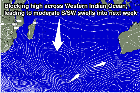 Next week onwards (Sep 1 onwards)
A strong blocking high across the Western Indian Ocean and a node of the Long Wave Trough positioned just south-west of WA will setup a regime of S/SW swells into next week and beyond. Size wise we're only looking at medium pulses through most of next week, with some more size on the cards for the following weekend. We'll look at this again on Thursday though.
16 day Bali Forecast Graph
16 day East Java Forecast Graph
16 day Sumbawa Forecast Graph
Comments
Bummer no more 4 metre swells just 2 metres ahead !
0500 27th August
NW Cape (Nganhurra FPSO)
Significant Swell 3.9m
H Max 6.0m
14.3 sec period
231.8 degrees
What a great run of waves, lucky buggers;)
Welly u read my mind . Wanted to ask but didnt want annoy the captain
Baliwaves has a few largish Ulu pics up.
Nah all good Caml, I just go help myself now, hehe.
Geez what awesome conditions it has been up these ways the last 3 days ever since the peak in swell, as regards to light winds, nice clean lines. I'm sure it would of been good down a south a little ;) Even on the land fall which I can see.
Jumped up again overnight, late yeaterday arvo dropped off quite quick.
Blowin your arms must be so tired by now;)
Great info Welly, awesome for tracking the swell!
Hitting my second wind Welly.
Hey Craig, it's been a pretty incredible season for Indo, particularly with the size, but also consistency. I've been keeping a pretty close watch on all your reports for the season. I know it's a long way out, but would you be reasonably confident that this pattern is going to continue through September?
I'm not that interested in the continuation of MASSIVE swell, but as I have a Ment's trip from early (10th) 'till the end of Sept, it would be nice to have some peace of mind that it's not going to stop!! Obviously I'll keep a eye on reports closer to departure.
@ Welly, when are you home next mate? Hope all is well out there and you're getting sleep with all this swell.
Start of September looks really slow with two successive blocking systems dominating the Western Indian Ocean, with a good but not overly large pulse for the 7th/8th/9th but onwards from here it's hard to say.
I'd say it's better seeing this blocking setup early September as it'll likely dissipate into the second half of the month hopefully.
Thanks Craig, I'll keep an eye on the reports. Much appreciated.
Craig, what's your thoughts on when the next node of the LWT will push out into the Indian? I'm hoping you're going to say mid-late Sept!!!! :)
Haha, wow, that's way too far away to call now.
Looking at current forecasts, a new strengthening node is due South West of WA early September 2nd/3rd (producing the S/SW groundswell for the 7-9th) before weakening and moving off under Australia.
LWT Tuesday afternoon 2nd Sep

But then behind this a new strengthening node is forecast around the 6th of September more across the South-Western Indian Ocean and this should provide some increased activity from mid-September onwards from the SW.
This is very long-range forecasting though, some 2-3 weeks ahead, so treat it as that :)
LWT Saturday night 6th Sep
Thanks for the very LONG range forecast Craig. I guess I was asking more about how long it takes for the nodes to traverse around the southern ocean.
Looking at that 6th Sept one, you would expect it to steer some swell up to Indo from that node just off the african continent, and allowing for 4-5 days travel time, you would expect this to be arriving sometime around 11th/12th Sept in Indo? Current super long range GFS has some new swell arriving in Indo around Friday 12th, so this appears to line up reasonably well with that LWT chart above.
My other question is what dictates the strength of the swell produced from these nodes of the LWT? I know it's the wind strength, fetch length and duration, But what I'm asking is how can one tell this from the LWT nodes? All the nodes above look the same to me?
Also, any chance you could provide the link to the LWT charts again please?
Ah, speed is dependant on how many nodes there are, and the more nodes the faster it travels. So at the moment it would be moving quicker than if there were only 3 say nodes around the Southern Hemisphere.
The old links to the LWT creating charts don't work any more sorry. There are other sources, but the charts I have just shown are our own which will be available soon.
No worries Craig, I'm not sure if it helps you guys, at least I get to give some solid right there, right now info on the board.
Geez its hard sometimes looking at this beautiful swell and weather roll by, only knowing 20k's landfall is pumping.
To top it off back home on the 1st to miss a great August swell in SE Qld. Oh well, cant win them all.
Fitzy bet you been getting waves up there;)
Yeah Welly, on the coast has been getting bugger all, but out in my playground has been really, really good. :)
Stay safe.
1500 NW Cape (Nganhurra FPSO)
Sig Swell 3.1m
H Max 4.8m
16.7 secs
231 degrees.
This swell to me seemed like a silent swell, no wind all day and just sneaking past.
Did not seem as strong and lined up as the last one 3-4 days ago, but for some reason had higher parameters...?Especially this morning, Any thoughts Craig
Watching it run past 20ks out to sea,
Maybe no wind makes it feel sneaky or weaker
Maybe fanning offshores like the other day makes it feel stronger/more power or just lined up...?
Weird..... 1
Wow that is a really strong signal Welly, core winds were a touch stronger with this system and this would of resulted in slightly longer periods, but more focussed towards the southern states of Australia.
You wouldn't be able to get a time series of the last week would you? Be great to look at and hindcast the two different swells.
Time series of last week...?Not sure what you mean Craig..? I'm not sure if I can get ol Captain mate to back track will ask ;)
The swell has a longer period this arvo compared to this morning.
Like I said comparing the sizes with the other day this swell does not even look as solid...???
Would like to know the size late tomorrow in Indo, interesting.
GF, no fishing just been watching lots of whales and their calves go home, back to the South;) Awesome sight I walk up the boat with them 250 meters watching them in the water clear as day.
Ah, like hour by hour recording of the data from the past week. They may have the records noted down or a graph.
Interesting re the swell not looking as solid, but the readings were larger than last time weren't they? 4m compared to 4.8m yes? Maybe the wind blowing over the ocean last time made it look more defined.
"Maybe the wind blowing over the ocean last time made it look more defined."
Yeah thats what I reckon.
See what I can do with some data as regards the 23rd and today 27th..? Not sure how I can get it to you tho, scan and email....??????
Yeah email through to craig@swellnet.com.au and that'd be great!
Do you guys fish off them Welly?
I could murder a Golden Gaytime right now.
Pretty content and hungry?
What kind of a perverse kink in the design of humanity is it to crave the one desire you can't satisfy ? Apart from the shimmering mirage of a toffee and vanilla ice cream dipped in chocolate and rolled in honeycomb pieces dancing in front of my eyes , life is pretty fucking grand.
Ah, aint those the days!
Geez what a week of waves for ya Blowin, awesome swell trains and wind/weather.
Was thinking of ya the whole time, lucky man for sure.
Golden Gaytimes;)
Dying swell, new moon with tidal change at sunrise..... Fish will be on. One door shuts and another opens. Huey you're a legend.
Get into it Blowin. Life is sounding pretty good for you right now. Remember, no regrets. One day later in life, you will look back at times like this and it will bring a big smile to your face.
Too true Fitzroy. Life's too short. Doesn't sound like you're doing too hard either mate , it's a good life eh !
BTW Swellnet crew - nice calls on the surf forecasts, you've been nailing it. Great work and thanks heaps.