The South West will shine this period with plenty of quality surf days.
Primary tabs
/reports/forecaster-notes/western-australia/2025/03/19/plenty-quality-surf-days-ahead
Craig
Wednesday, 19 March 2025
/reports/forecaster-notes/western-australia/2025/03/17/mixed-week-best-thursday
Craig
Monday, 17 March 2025
The coming week isn't great for the metro locations, better in the South West.

/reports/forecaster-notes/western-australia/2025/03/14/solid-tomorrow-then-lots-mid-sized-swell
freeride76
Friday, 14 March 2025
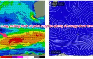
As stated on Wed, the Indian Ocean is quite active with a long fetch of W’ly gales currently SW of the state and moving E. That will supply reinforcing pulses of SW swell later in the weekend into Mon .
/reports/forecaster-notes/western-australia/2025/03/12/plenty-swell-ahead-offshores-autumn-takes-hold
freeride76
Wednesday, 12 March 2025
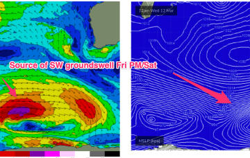
Into next week and a long fetch of gale force winds in the screaming 50’s later this week supplies plenty of energy into next week, although nothing major. The position of the long wave trough favours Victoria as those winds form low pressure and aim up more directly at SE Aus.

/reports/forecaster-notes/western-australia/2025/03/10/lots-good-windows-ahead-although-winds-get
freeride76
Monday, 10 March 2025
The Indian Ocean is in an active phase with a storm track concentrated on disturbances SW of Heard Island and tracking below the state maintaining intensity. Locally, a ridge under the state is being enhanced by a trough moving down the coast from the Gascoyne, eventually forming a low off the SW corner before it moves inland again.
/reports/forecaster-notes/western-australia/2025/03/07/multiple-strong-swells-inbound
Craig
Friday, 7 March 2025
From Sunday we've got multiple strong swells inbound though winds are a little tricky at times.
/reports/forecaster-notes/western-australia/2025/03/05/great-today-fun-tomorrow
Craig
Wednesday, 5 March 2025
Make the most of the current swell, though there is another good one for the weekend but with less favourable winds.
/reports/forecaster-notes/western-australia/2025/03/03/active-period-windy-best-wednesday
Craig
Monday, 3 March 2025
Tomorrow will be windy with building levels of swell while Wednesday looks the pick, though with strong, tricky offshore winds. Another good swell is due Sunday but with wind.
/reports/forecaster-notes/western-australia/2025/02/28/new-swell-the-weekend-onshore-it-peaks-better
Craig
Friday, 28 February 2025
The weekend will be decent across the South West each morning while a bigger swell is due into next week with strong offshore winds as it peaks.
/reports/forecaster-notes/western-australia/2025/02/26/poor-tomorrow-better-friday
Craig
Wednesday, 26 February 2025
We've got a few more pulses of swell to come this period, cleanest as they ease.. as always.