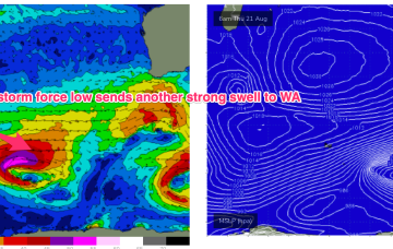
The next swell generated by a compact but storm force low tracking from Heard Is towards WA fills in Sun.
Primary tabs
/reports/forecaster-notes/western-australia/2025/08/22/swells-easing-temporarily-good-winds-remain
freeride76
Friday, 22 August 2025
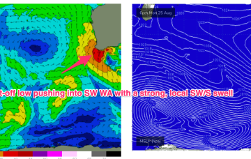
/reports/forecaster-notes/western-australia/2025/08/20/stormy-large-swells-take-some-time-settle-down
freeride76
Wednesday, 20 August 2025
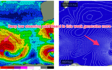
A complex low with multiple centres and fronts is aiming fetches of gales to severe gales at WA over the next 36hrs.
/reports/forecaster-notes/western-australia/2025/08/18/large-and-stormy-week
freeride76
Monday, 18 August 2025
A deepening, complex polar low then spins off multiple fronts all slingshotting NE on an active sea state.
/reports/forecaster-notes/western-australia/2025/08/15/small-clean-weekend-large-swell-next-week
Craig
Friday, 15 August 2025
Swells due later Sunday and Monday arrive a little too late for the favourable winds. We'll then see large, onshore surf develop mid-week.
/reports/forecaster-notes/western-australia/2025/08/13/poor-tomorrow-improving-friday
Craig
Wednesday, 13 August 2025
The end of the week will remain onshore for the South West, improving on the weekend with a one decent pulse of swell.
/reports/forecaster-notes/western-australia/2025/08/11/generally-average-period-ahead
Craig
Monday, 11 August 2025
There's been no improvement to the outlook with a couple of windows to the north and one in the South West come the weekend.
/reports/forecaster-notes/western-australia/2025/08/08/average-outlook-ahead
Craig
Friday, 8 August 2025
The coming outlook is average with generally poor winds and only one large swell for the weekend.
/reports/forecaster-notes/western-australia/2025/08/06/make-the-most-today-and-tomorrow
Craig
Wednesday, 6 August 2025
The coming period isn't great at all with smaller swells and average winds.
/reports/forecaster-notes/western-australia/2025/08/04/great-surf-developing-the-week-unfolds
Craig
Monday, 4 August 2025
We've got improving conditions and more large surf on the way with the waves expected to become great from Wednesday.
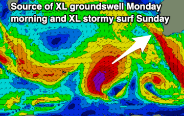
/reports/forecaster-notes/western-australia/2025/08/01/xl-stormy-weekend-great-mid-late-next-week
Craig
Friday, 1 August 2025
The weekend is a write-off with improving surf across metro locations early week, better across the South West from Wednesday onwards.